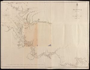
Creator
Haack, Hermann, 1872-1966, cartographer
Container / Volume
BRBL_00022
Published / Created
1902
Call Number
26 1902A
Format
Digital Collection / Online / Cartographic / Maps & GIS
Found In
Access
Public
Alternative Title
Commonwealth of Australia :

Creator
Huntington, Ellsworth, 1876-1947
Container / Volume
Box 11
Published / Created
Early 1900s
Call Number
MS 1
Format
Digital Collection / Online
Found In
Access
Public

Container / Volume
BRBL_00022
Published / Created
[18--]
Call Number
26 1860
Format
Digital Collection / Online / Cartographic / Maps & GIS
Found In
Access
Public
Alternative Title
Karte v. Festland Australia and Karte v[on] Festland Australia

Creator
Great Britain. Hydrographic Department, cartographer
Description
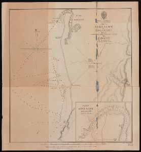
Stokes's Discoveries in Australia (1846). Imperfect: mutilated. Inset Nautical chart of Port Adelaide
Published / Created
March 23rd 1846.
Call Number
BrSides 2019 97
Format
Digital Collection / Online / Cartographic / Maps & GIS
Found In
Access
Public
Subject (Name)
Bate, R. B. (Robert Brettell), bookseller, J. & C. Walker (Firm), engraver, and Stokes, John Lort, 1811-1885. Discoveries in Australia.
Subject (Topic)
Nautical charts--Australia--Holdfast Bay (S.A. : Bay) and Nautical charts--Australia--Port Adelaide Region (S.A.)
Creator
Great Britain. Hydrographic Dept and Stokes, J. Lort (John Lort), 1811-1885
Container / Volume
BRBL_00023
Published / Created
Aug. 16th. 1852 [i.e. 1865]
Call Number
26cea 1851A
Format
Digital Collection / Online / Cartographic / Maps & GIS
Found In
Access
Public

Creator
Great Britain. Hydrographic Dept and Potter, J. D
Container / Volume
BRBL_00023
Published / Created
Aug. 16th 1852 [i.e. 1865]
Call Number
26cea 1851C
Format
Digital Collection / Online / Cartographic / Maps & GIS
Found In
Access
Public

Creator
Great Britain. Hydrographic Department, author
Container / Volume
BRBL_00021
Call Number
254cea 1886
Format
Digital Collection / Online / Cartographic / Maps & GIS
Found In
Access
Public

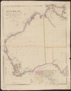
Creator
Wyld, James, 1812-1887
Container / Volume
BRBL_00022
Description
on linen. Sheet measures 68 x 101 cm. Map of southern Australia with notes on the topography and gold
Published / Created
[1853]
Call Number
26 1852
Format
Digital Collection / Online / Cartographic / Maps & GIS
Found In
Access
Public
Container / Volume
Box 108 | Slide: 80
Published / Created
1936 {id=286414}
Call Number
GEN MSS 475
Format
Digital Collection / Online / Text
Found In
Access
Public

Creator
Arrowsmith, John, 1790-1873
Container / Volume
BRBL_00022
Published / Created
1st. Jany. 1850.
Call Number
26 1850A
Format
Digital Collection / Online / Cartographic / Maps & GIS
Found In
Access
Public
Creator
Stokes, John Lort, 1811-1885, cartographer
Description
At foot of page: J. Arrowsmith. From John Lort Stokes's Discoveries in Australia (1846).
Published / Created
1846
Call Number
BrSides 2019 98
Format
Digital Collection / Online / Cartographic / Maps & GIS
Found In
Access
Public
Subject (Name)
Arrowsmith, John, 1790-1873 and Stokes, John Lort, 1811-1885. Discoveries in Australia.

Container / Volume
BRBL_00022
Published / Created
1847
Call Number
26 1847
Format
Digital Collection / Online / Cartographic / Maps & GIS
Found In
Access
Public

Creator
Great Britain. Hydrographic Dept and Stokes, J. Lort (John Lort), 1811-1885
Container / Volume
BRBL_00023
Published / Created
Aug. 16th. 1852 [i.e. 1865]
Call Number
26cea 1851B
Format
Digital Collection / Online / Cartographic / Maps & GIS
Found In
Access
Public

Creator
Great Britain. Hydrographic Dept and Potter, J. D
Container / Volume
BRBL_00023
Published / Created
Aug. 16th. 1852 [i.e. 1862]
Call Number
26cea 1851D
Format
Digital Collection / Online / Cartographic / Maps & GIS
Found In
Access
Public
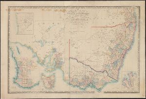
Creator
New South Wales. Department of Lands
Description
of Australia, 1911, by the Authority of the Hon. King O'Malley, Minister of State for Home Affairs." Inset
Published / Created
1911
Call Number
BrSides Elephant Folio 2018 30
Format
Digital Collection / Online / Cartographic / Maps & GIS
Found In
Access
Public

Container / Volume
BRBL_00294
Published / Created
1883
Call Number
556FD 1883
Format
Digital Collection / Online / Cartographic / Maps & GIS
Found In
Access
Public

Creator
Dayman, J. M, Great Britain. Hydrographic Dept, J. & C. Walker (Firm), Obree, W. H, Potter, J. D. (John D.), Simpson, H. G, Stanley, Owen, 1811-1850, and Yule, C. B
Container / Volume
BRBL_00022
Published / Created
June 1st, 1855 [i.e. 1911?]
Call Number
261cea T636 1855
Format
Digital Collection / Online / Cartographic / Maps & GIS
Found In
Access
Public

Creator
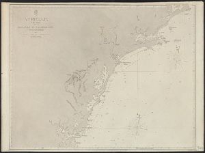
Stokes, John Lort, 1811-1885, cartographer
Description
From John Lort Stokes's Discoveries in Australia (1846). Lower left-hand corner: :Captn Stokes
Published / Created
Feby 18th 1846.
Call Number
BrSides 2019 96
Format
Digital Collection / Online / Cartographic / Maps & GIS
Found In
Access
Public
Subject (Name)
Arrowsmith, John, 1790-1873, publisher, Beagle (Ship), and Stokes, John Lort, 1811-1885. Discoveries in Australia.

Creator
Arrowsmith, John, 1790-1873, cartographer
Description
From John Lort Stokes's Discoveries in Australia (1846). Relief shown by hachures.
Published / Created
1846
Call Number
BrSides 2019 94
Format
Digital Collection / Online / Cartographic / Maps & GIS
Found In
Access
Public
Subject (Name)
Stanley, Owen, surveyor, Stokes, John Lort, 1811-1885. Discoveries in Australia., and Thomas and William Boone, publisher

Container / Volume
BRBL_00023
Published / Created
1855
Call Number
26cea 1843A
Format
Digital Collection / Online / Cartographic / Maps & GIS
Found In
Access
Public

Creator
Evans, F. J. (Frederick J.), Great Britain. Hydrographic Dept, J. & C. Walker (Firm), Potter, J. D. (John D.), and Washington Capt
Container / Volume
BRBL_00023
Published / Created
Decr. 12th 1860.
Call Number
26cea 1860
Format
Digital Collection / Online / Cartographic / Maps & GIS
Found In
Access
Public

Creator
Stokes, John Lort, 1811-1885, cartographer.
Description
At head of title: Australia N.W. Coast. Coordinates not present on map and are approximated
Published / Created
Apr. 5, 1845.
Call Number
BrSides Double Folio 2019 107
Format
Digital Collection / Online / Cartographic / Maps & GIS
Found In
Access
Public
Alternative Title
Australia N.W. coast :
Subject (Topic)
Nautical charts--Australia--Northern Territory.
Container / Volume
BRBL_00023
Published / Created
1855
Call Number
26cea 1843
Format
Digital Collection / Online / Cartographic / Maps & GIS
Found In
Access
Public

Container / Volume
BRBL_00023
Published / Created
1855
Call Number
26cea 1843B
Format
Digital Collection / Online / Cartographic / Maps & GIS
Found In
Access
Public

Creator
Stokes, John Lort, 1811-1885, cartographer.
Description
At head of title: Australia Gulf of Carpentaria. Coordinates not present on map
Published / Created
April 10, 1845.
Call Number
BrSides Double Folio 2019 108
Format
Digital Collection / Online / Cartographic / Maps & GIS
Found In
Access
Public
Alternative Title
Australia Gulf of Carpentaria :
Subject (Topic)
Albert River (Qld.)--Maps., Albert River (Qld.)--Navigation--Maps., and Nautical charts--Australia--Queensland.
