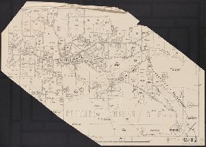
Creator
Western Australia. Department of Lands and Surveys
Container / Volume
BRBL_00023
Published / Created
1921
Call Number
2651 R197 1921
Format
Digital Collection / Online / Cartographic / Maps & GIS
Access
Public
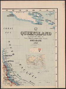
Creator
Queensland. Dept. of Public Lands
Container / Volume
BRBL_00022
Description
Inset: The world showing relative position of Australia.
Published / Created
1921
Call Number
261 1921A
Format
Digital Collection / Online / Cartographic / Maps & GIS
Access
Public
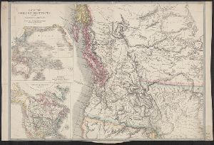
Creator
Richards, Thomas, Sharp, G. W, and Tayler, J., fl. 1861-1875
Container / Volume
BRBL_00022
Description
Copies 1-2 affixed to booklet. Inset: Australia. Scale [ca. 1:60 000 000]. On verso: "New South
Published / Created
1876
Call Number
262ca 1876
Format
Digital Collection / Online / Cartographic / Maps & GIS
Found In
Access
Public
Alternative Title
Mineral map and general statistics of New South Wales, Australia and Mineral map and general statistics of New South Wales, Australia.

Container / Volume
BRBL_00272
Description
Includes inset of "New Holland" [i.e. Australia]. On verso: 39. Relief shown pictorially.
Published / Created
[1794?]
Call Number
50 1794
Format
Digital Collection / Online / Cartographic / Maps & GIS
Found In
Access
Public

Creator
Wyld, James, 1812-1887
Container / Volume
BRBL_00620
Description
and Australia" and "British possessions in America." Library's copy 2 dissected and mounted on linen, 50 x 70 cm
Published / Created
April 10th 1845.
Call Number
846 1845
Format
Digital Collection / Online / Cartographic / Maps & GIS
Found In
Access
Public
Alternative Title
British possessions in America. and Map to shew the communication from the N.W. Coast of America to China and Australia

Creator
Goos, Pieter, approximately 1616-1675
Abstract
Sea chart of Australia (Hollandia Nova) Southeast Asia, China, Japan, Korea and India. Three Dutch
Call Number
Lanman 27 1666
Format
Digital Collection / Online / Cartographic / Maps & GIS
Found In
Access
Public

Published / Created
circa 1995-2017
Call Number
VRC 1990a
Format
Digital Collection / Online
Found In
Access
Public

Published / Created
circa 1995-2017
Call Number
VRC 1990a
Format
Digital Collection / Online
Found In
Access
Public

Published / Created
circa 1995-2017
Call Number
VRC 1990a
Format
Digital Collection / Online
Found In
Access
Public

Published / Created
circa 1995-2017
Call Number
VRC 1990a
Format
Digital Collection / Online
Found In
Access
Public

Published / Created
circa 1995-2017
Call Number
VRC 1990a
Format
Digital Collection / Online
Found In
Access
Public

Published / Created
circa 1995-2017
Call Number
VRC 1990a
Format
Digital Collection / Online
Found In
Access
Public

Creator
Kitchin, Thomas, d. 1784
Container / Volume
BRBL_00681
Description
Cross collection no. 43. Map of the world showing wind patterns and incomplete outline of Australia
Published / Created
1760?]
Call Number
11 1755A
Format
Digital Collection / Online / Cartographic / Maps & GIS
Found In
Access
Public

Creator
Bougainville, Louis-Antoine de, comte, 1729-1811
Description
]. Prime meridian: Paris. Watermark. World map showing route of the Boudeuse and the Etoile. Australia
Published / Created
[1771]
Call Number
BrSides Folio 2019 83
Format
Digital Collection / Online / Cartographic / Maps & GIS
Found In
Access
Public

Creator
Slight, James and Victoria. Dept. of Crown Lands and Survey
Container / Volume
BRBL_00023
Description
Inset: Map of Australia and adjacent islands. Scale [ca. 1:35,000,000]. Map of Victoria showing
Published / Created
1875
Call Number
263 1875
Format
Digital Collection / Online / Cartographic / Maps & GIS
Found In
Access
Public

Creator
Robert de Vaugondy, Gilles, 1688-1766
Container / Volume
BRBL_00681
Description
of Australia joining Van Diemen's Land to d'Esprit. Title in decorative frame; colour-coded according to major
Published / Created
1761
Call Number
11 1761
Format
Digital Collection / Online / Cartographic / Maps & GIS
Found In
Access
Public

Creator
Geographisches Institut (Weimar, Thuringia, Germany), Kiepert, Heinrich, 1818-1899, and Weiland, C. F. (Carl Ferdinand), -1847, cartographer
Container / Volume
BRBL_00022
Description
Süd-Australia. Prime meridians: Ferro, Greenwich and Paris. Top right-hand corner: "67".
Published / Created
[1855?]
Call Number
26 1855
Format
Digital Collection / Online / Cartographic / Maps & GIS
Found In
Access
Public

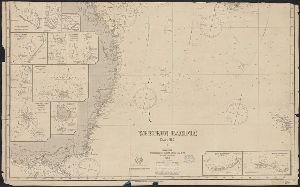
Creator
Imray, James F. (James Frederick), 1829?-1891, cartographer and James Imray and Son, issuing body
Container / Volume
BRBL_00021
Description
Hydrographic chart of the western Pacific Ocean, including eastern Australia, Papua New Guinea
Call Number
23cea 1886
Format
Digital Collection / Online / Cartographic / Maps & GIS
Found In
Access
Public
Creator
Robert de Vaugondy, Gilles, 1688-1766.
Container / Volume
BRBL_00023A
Description
-west coast of Australia. From: Atlas universel / par m. Robert geographe et Robert de Vaugondy son fils
Published / Created
[1757-1786?]
Call Number
27 1750
Format
Digital Collection / Online / Cartographic / Maps & GIS
Found In
Access
Public

Creator
Hill, Nathaniel, 1708-1768
Description
pocket globe showing the tracks of Anson's voyage, 1740-1744. Australia is drawn according to the Dutch
Published / Created
1754.
Call Number
Globe 45
Format
Digital Collection / Online / Cartographic Three Dimensional Form
Found In
Access
Public

Creator
Sconall, Tompson, M.D.
Description
that reads "South Australia". Above the scene, in the upper horizontal border, is the motto Omnia Deus Dat.
Format
Digital Collection / Online / Images
Found In
Access
Public

Creator
Robert de Vaugondy, Gilles, 1688-1766.
Description
, Indo-Chinese peninsula, and north-west coast of Australia. Includes inset map. Inset: Isles Marianes
Published / Created
1750
Call Number
BrSides Double Folio 2017 6
Format
Digital Collection / Online / Cartographic / Maps & GIS
Found In
Access
Public

Creator
Reed, Cyrus Adams
Abstract
of the globe trotter," 30 pages. Reed writes about his travels to South Africa, Australia, Hong Kong, Ceylon
Description
, South Africa in 1896; to Sydney, Australia, Hong Kong, Ceylon, and South Africa in 1897; and to Durban
Published / Created
[1906?]
Call Number
WA MSS S-3030 R25131
Format
Digital Collection / Online / Text / Archives or Manuscripts
Access
Public

Creator
Ridge, Lola, 1883-1941
Abstract
Lola Ridge was an American poet born in Ireland and raised in Australia. Her published works and The nine letters contain thanks for positive reviews of Ridge's work by Jones, and praise of Evelyn
Container / Volume
Box 1 | Folder 2
Published / Created
[ca. 1928 March 26]-1930 January 20
Call Number
YCAL MSS 73
Format
Digital Collection / Online / Mixed Material
Access
Public
