- No8
Digital Collections Search Results
Container / Volume
BRBL_00634
Published / Created
1898
Call Number
848 T15 1898
Format
Digital Collection / Online / Cartographic / Maps & GIS
Found In
Access
Public

Creator
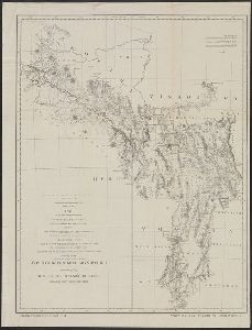
Warren, Gouverneur Kemble, 1830-1882
Container / Volume
BRBL_00534
Published / Created
1858?]
Call Number
80 1857E
Format
Digital Collection / Online / Cartographic / Maps & GIS
Found In
Access
Public
Subject (Topic)
Pacific railroads--Explorations and surveys--Maps and Railroads--West (U.S.)--Maps

Creator
Warren, Gouverneur Kemble, 1830-1882
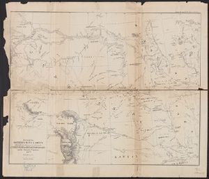
Container / Volume
BRBL_00534
Description
of explorations in Nebraska and Dakota in the years 1855-'56-'57," originally printed in the appendixes
Published / Created
1858]
Call Number
80 1857D
Format
Digital Collection / Online / Cartographic / Maps & GIS
Found In
Access
Public
Subject (Name)
United States. Army. Corps of Topographical Engineers. Preliminary report of explorations and United States. Office of Explorations and Surveys

Creator
United States. Army. Corps of Engineers
Container / Volume
BRBL_00506
Description
, many still remaining en route." In upper margin: Explorations Preliminary report of explorations
Published / Created
1872?]
Call Number
7821 1872
Format
Digital Collection / Online / Cartographic / Maps & GIS
Found In
Access
Public
Alternative Title
Explorations in Nevada and Arizona. and Preliminary topographical map embracing in skeleton a portion only of the notes from surveys made
Subject (Name)
Lockwood, Daniel W, Lyle, D. A, Nell, Louis, United States. Army. Corps of Engineers. Preliminary report of explorations in Nevada and Arizona, and Wheeler, George M. (George Montague), 1842-1905
Creator
Warren, Gouverneur Kemble, 1830-1882
Container / Volume
BRBL_00534
Description
explorations from 1820 to 1855 and locations of Indian tribes.
Published / Created
1856]
Call Number
80 1855B
Format
Digital Collection / Online / Cartographic / Maps & GIS
Found In
Access
Public
Creator
Geographical Surveys West of the 100th Meridian (U.S.)
Container / Volume
BRBL_00537
Description
, & 1876." Relief shown by hachures. Shows routes of explorations and surveys of the Army officers
Published / Created
1877
Call Number
80b 1877
Format
Digital Collection / Online / Cartographic / Maps & GIS
Found In
Access
Public

Description
: Map showing the route pursued by the exploring expedition to New Mexico and the southern Rocky
Published / Created
1846?]
Call Number
Zc20 846un
Format
Digital Collection / Online / Mixed Material / Books
Found In
Beinecke Rare Book and Manuscript Library > Message from the president of the United States : in compliance with a resolution of the Senate, communicating a report of an expedition led by Lieutenant Abert, on the upper Arkansas and through the country of the Camanche Indians, in the fall of the year 1845.
Access
Public

Description
plates. Caption title. Map entitled: Map showing the route pursued by the exploring expedition to New
Published / Created
1846?]
Call Number
Zc20 846un
Format
Digital Collection / Online / Images / Books
Found In
Beinecke Rare Book and Manuscript Library > Message from the president of the United States : in compliance with a resolution of the Senate, communicating a report of an expedition led by Lieutenant Abert, on the upper Arkansas and through the country of the Camanche Indians, in the fall of the year 1845.
Access
Public
