- No6
Digital Collections Search Results
Container / Volume
BRBL_00474
Description
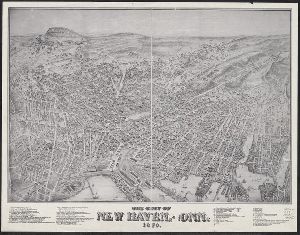
A view of New Haven. Has list of 51 important places. Indexed. Shows buildings, trees, houses
Published / Created
1879
Call Number
766am N46 1879V
Format
Digital Collection / Online / Cartographic / Maps & GIS
Access
Public

Container / Volume
BRBL_00474
Description
A view of New Haven. Has list of 51 important places. Indexed. Shows buildings, trees, houses
Published / Created
1879
Call Number
766am N46 1879V
Format
Digital Collection / Online / Cartographic / Maps & GIS
Access
Public
Container / Volume
BRBL_00448
Description
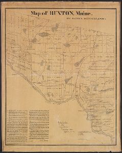
showing divisions, ranges and lots, roads, railroads, sites of houses prior to 1800, etc.
Published / Created
1871
Call Number
761 B98 1870
Format
Digital Collection / Online / Cartographic / Maps & GIS
Access
Public
Creator
Dearborn, Benjamin, 1754-1838
Container / Volume
BRBL_00455
Description
-Press, lately invented by Benjamin Dearborn." Removed from Massachusetts House Document no. 18 of June 1814
Published / Created
[1814]
Call Number
764 B65 1814A
Format
Digital Collection / Online / Cartographic / Maps & GIS
Found In
Access
Public

Creator
Geo. W. Stadly & Co., cartographer
Description
cartouche with views of the Old State House and Faneuil Hall. Includes index for streets and buildings
Published / Created
©1896.
Call Number
764 B65 +1896
Format
Digital Collection / Online / Cartographic / Maps & GIS
Found In
Access
Public

Container / Volume
BRBL_00447
Description
Decorative cartouche shows sloop loading lumber off rocky coast; shore with houses, pine tre London
Published / Created
[1801]
Call Number
761 1801
Format
Digital Collection / Online / Cartographic / Maps & GIS
Found In
Access
Public
