- No[remove]23
Digital Collections Search Results
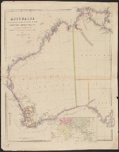
Creator
Arrowsmith, John, 1790-1873
Container / Volume
BRBL_00022
Description
Map of eastern Australia (east of 130 ̊long.), considerably more detailed than his 1842 version
Published / Created
1st Jany. 1850.
Call Number
26 1850B
Format
Digital Collection / Online / Cartographic / Maps & GIS
Found In
Access
Public
Subject (Topic)
Counties--Australia, Eastern--Maps

Creator
Arrowsmith, John, 1790-1873, cartographer
Description
From John Lort Stokes's Discoveries in Australia (1846). Includes index of counties and notes
Published / Created
Apl. 1st 1846.
Call Number
BrSides 2019 93
Format
Digital Collection / Online / Cartographic / Maps & GIS
Found In
Access
Public
Subject (Name)
Beagle Expedition--(1831-1836)--Maps. and Stokes, John Lort, 1811-1885. Discoveries in Australia.
Subject (Topic)
Counties--Australia--New South Wales--Maps., Counties--Australia--Western Australia--Maps., and Discoveries in geography

Creator
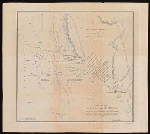
Arrowsmith, John, 1790-1873, cartographer
Description
) in Western Australia, showing coastal soundings and topography of an area of approx. 250 square miles inland
Published / Created
1846
Call Number
BrSides 2019 95
Format
Digital Collection / Online / Cartographic / Maps & GIS
Found In
Access
Public
Subject (Name)
Beagle (Ship), Grey, George,--1812-1898, Grey, George,--1812-1898--Travel--Australia--Western Australia--Maps., Stokes, John Lort, 1811-1885. Discoveries in Australia., and Stokes, John Lort,--1811-1885--Travel--Australia--Western Australia--Maps.
Subject (Topic)
Discoveries in geography, Nautical charts--Australia--Champion Bay (W.A.), and Voyages and travels
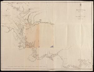
Creator
Great Britain. Admiralty
Container / Volume
BRBL_00022
Published / Created
1894 [i.e. 1903?]
Call Number
261cea T636 1894
Format
Digital Collection / Online / Cartographic / Maps & GIS
Found In
Access
Public

Creator
Great Britain. Hydrographic Dept and Stokes, J. Lort (John Lort), 1811-1885
Container / Volume
BRBL_00023
Published / Created
Aug. 16th. 1852 [i.e. 1865]
Call Number
26cea 1851A
Format
Digital Collection / Online / Cartographic / Maps & GIS
Found In
Access
Public

Creator
Great Britain. Hydrographic Dept and Potter, J. D
Container / Volume
BRBL_00023
Published / Created
Aug. 16th 1852 [i.e. 1865]
Call Number
26cea 1851C
Format
Digital Collection / Online / Cartographic / Maps & GIS
Found In
Access
Public

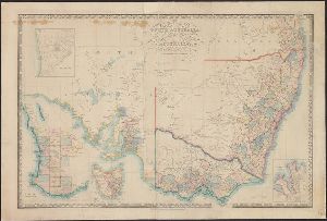
Creator
Wyld, James, 1812-1887
Container / Volume
BRBL_00022
Description
on linen. Sheet measures 68 x 101 cm. Map of southern Australia with notes on the topography and gold
Published / Created
[1853]
Call Number
26 1852
Format
Digital Collection / Online / Cartographic / Maps & GIS
Found In
Access
Public
Creator
Arrowsmith, John, 1790-1873
Container / Volume
BRBL_00022
Published / Created
1st. Jany. 1850.
Call Number
26 1850A
Format
Digital Collection / Online / Cartographic / Maps & GIS
Found In
Access
Public
Creator
Stokes, John Lort, 1811-1885, cartographer
Description
At foot of page: J. Arrowsmith. From John Lort Stokes's Discoveries in Australia (1846).
Published / Created
1846
Call Number
BrSides 2019 98
Format
Digital Collection / Online / Cartographic / Maps & GIS
Found In
Access
Public
Subject (Name)
Arrowsmith, John, 1790-1873 and Stokes, John Lort, 1811-1885. Discoveries in Australia.

Container / Volume
BRBL_00022
Published / Created
1847
Call Number
26 1847
Format
Digital Collection / Online / Cartographic / Maps & GIS
Found In
Access
Public

Creator
Great Britain. Hydrographic Dept and Stokes, J. Lort (John Lort), 1811-1885
Container / Volume
BRBL_00023
Published / Created
Aug. 16th. 1852 [i.e. 1865]
Call Number
26cea 1851B
Format
Digital Collection / Online / Cartographic / Maps & GIS
Found In
Access
Public

Creator
Great Britain. Hydrographic Dept and Potter, J. D
Container / Volume
BRBL_00023
Published / Created
Aug. 16th. 1852 [i.e. 1862]
Call Number
26cea 1851D
Format
Digital Collection / Online / Cartographic / Maps & GIS
Found In
Access
Public
Container / Volume
BRBL_00294
Published / Created
1883
Call Number
556FD 1883
Format
Digital Collection / Online / Cartographic / Maps & GIS
Found In
Access
Public

Creator
Dayman, J. M, Great Britain. Hydrographic Dept, J. & C. Walker (Firm), Obree, W. H, Potter, J. D. (John D.), Simpson, H. G, Stanley, Owen, 1811-1850, and Yule, C. B
Container / Volume
BRBL_00022
Published / Created
June 1st, 1855 [i.e. 1911?]
Call Number
261cea T636 1855
Format
Digital Collection / Online / Cartographic / Maps & GIS
Found In
Access
Public

Creator
Stokes, John Lort, 1811-1885, cartographer
Description
From John Lort Stokes's Discoveries in Australia (1846). Lower left-hand corner: :Captn Stokes
Published / Created
Feby 18th 1846.
Call Number
BrSides 2019 96
Format
Digital Collection / Online / Cartographic / Maps & GIS
Found In
Access
Public
Subject (Name)
Arrowsmith, John, 1790-1873, publisher, Beagle (Ship), and Stokes, John Lort, 1811-1885. Discoveries in Australia.

Container / Volume
BRBL_00023
Published / Created
1855
Call Number
26cea 1843A
Format
Digital Collection / Online / Cartographic / Maps & GIS
Found In
Access
Public

Creator
Evans, F. J. (Frederick J.), Great Britain. Hydrographic Dept, J. & C. Walker (Firm), Potter, J. D. (John D.), and Washington Capt
Container / Volume
BRBL_00023
Published / Created
Decr. 12th 1860.
Call Number
26cea 1860
Format
Digital Collection / Online / Cartographic / Maps & GIS
Found In
Access
Public

Creator
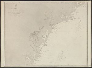
Stokes, John Lort, 1811-1885, cartographer.
Description
At head of title: Australia N.W. Coast. Coordinates not present on map and are approximated
Published / Created
Apr. 5, 1845.
Call Number
BrSides Double Folio 2019 107
Format
Digital Collection / Online / Cartographic / Maps & GIS
Found In
Access
Public
Alternative Title
Australia N.W. coast :
Subject (Topic)
Nautical charts--Australia--Northern Territory.
Container / Volume
BRBL_00023
Published / Created
1855
Call Number
26cea 1843
Format
Digital Collection / Online / Cartographic / Maps & GIS
Found In
Access
Public

Creator
Stokes, John Lort, 1811-1885, cartographer.
Description
At head of title: Australia Gulf of Carpentaria. Coordinates not present on map
Published / Created
April 10, 1845.
Call Number
BrSides Double Folio 2019 108
Format
Digital Collection / Online / Cartographic / Maps & GIS
Found In
Access
Public
Alternative Title
Australia Gulf of Carpentaria :
Subject (Topic)
Albert River (Qld.)--Maps., Albert River (Qld.)--Navigation--Maps., and Nautical charts--Australia--Queensland.

Container / Volume
BRBL_00272
Description
Includes inset of "New Holland" [i.e. Australia]. On verso: 39. Relief shown pictorially.
Published / Created
[1794?]
Call Number
50 1794
Format
Digital Collection / Online / Cartographic / Maps & GIS
Found In
Access
Public

Creator
Wyld, James, 1812-1887
Container / Volume
BRBL_00620
Description
and Australia" and "British possessions in America." Library's copy 2 dissected and mounted on linen, 50 x 70 cm
Published / Created
April 10th 1845.
Call Number
846 1845
Format
Digital Collection / Online / Cartographic / Maps & GIS
Found In
Access
Public
Alternative Title
British possessions in America. and Map to shew the communication from the N.W. Coast of America to China and Australia
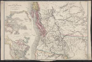
