- No7
Creator
Blankaart, Nikolaas, 1624-1703, cartographer.
Published / Created
[1652?]
Call Number
BrSides Folio 2017 6
Format
Digital Collection / Online / Cartographic / Maps & GIS
Found In
Access
Public
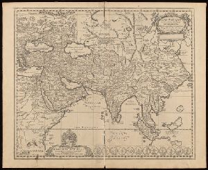
Creator
Münster, Sebastian, 1489-1552, cartographer.
Description
, and Asia and one map of the Biblical Middle East. Relief shown pictorially.
Published / Created
[1580?]
Call Number
BrSides Folio 2017 34
Format
Digital Collection / Online / Cartographic / Maps & GIS
Found In
Access
Public
Alternative Title
Universaltafel des situs Asiae, Africae und Europae, samt der gelegenhäit des lands Eden, wie auch

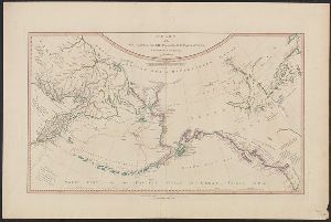
Creator
Delarochette, L. (Louis), 1731-1802, cartographer.
Published / Created
1794
Call Number
23 1794A
Format
Digital Collection / Online / Cartographic / Maps & GIS
Found In
Access
Public
Alternative Title
Chart of the northwest coast of America and the northeast coast of Asia, explored in the years 1778
Creator
Allard, Carel, 1648-ca. 1709.
Description
Britaniae, Scandinaviae, Poloniae, Moscoviae, Asiae, Americae et Africae : cum speciali indice, quo
Published / Created
1702]
Call Number
1973 Folio 18
Format
Digital Collection / Online / Cartographic / Maps & GIS
Found In
Beinecke Rare Book and Manuscript Library > Exactissima Asiae delineatio, in praecipuas regiones, ceterasq [cartographic material] : partes divisa, et denuo in lucem / edita per Carolum Allard, cum privilegio potentissimorum D.D. Ordinum Hollandiae & Westfriae ; extracta ex authenticis tabulis D. Nicolai Witsen, cos. Amst., et praecipuorum auctorum, cum consensu viri amplissimi ; Ph. Tiedeman, delin. ; G. v. Gouwen, sculp.
Access
Public

Creator
Goos, Pieter, approximately 1616-1675
Abstract
Sea chart of Australia (Hollandia Nova) Southeast Asia, China, Japan, Korea and India. Three Dutch
Call Number
Lanman 27 1666
Format
Digital Collection / Online / Cartographic / Maps & GIS
Found In
Access
Public

Creator
Sanson, Nicolas, 1600-1667, cartographer.
Published / Created
ca. 1702?]
Call Number
1973 Folio 18
Format
Digital Collection / Online / Cartographic / Maps & GIS
Found In
Beinecke Rare Book and Manuscript Library > [Est]ats de L'Empire du Grand Seigneur des Turcs Europe, en Asie, et en Afrique [cartographic material] : divise en tous ses Beglerbeglicz ou Gouvernements ou sont aussi remarques les Estats qui luy sont Tributaires dresse sur les plus nouvelles relations / par le Sr. Sanson ...
Access
Public
Alternative Title
Imperium Turcicum, complectens Europae, Asiae et Africae, Arabiae que regiones ac provincias

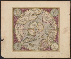
Creator
Mercator, Gerhard, 1512-1594, cartographer.
Description
to the north of Asia corrected. California is identified as Spanish territory, within the arctic circle.
Published / Created
[1605?]
Call Number
18 1605
Format
Digital Collection / Online / Cartographic / Maps & GIS
Found In
Access
Public