- No22
Container / Volume
BRBL_00004
Published / Created
[1733?]
Call Number
11 1733
Format
Digital Collection / Online / Cartographic / Maps & GIS
Found In
Access
Public

Creator
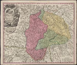
Zuerner, Adam Friedrich, 1680-1742
Container / Volume
BRBL_00686
Published / Created
[170-?]
Call Number
70 170X
Format
Digital Collection / Online / Cartographic / Maps & GIS
Found In
Access
Public

Creator
Wytfliet, Corneille.
Published / Created
1597
Call Number
1977 +400
Format
Digital Collection / Online / Cartographic / Maps & GIS
Found In
Access
Public
Container / Volume
BRBL_00229
Published / Created
1856
Call Number
40EF 1856
Format
Digital Collection / Online / Cartographic / Maps & GIS
Found In
Access
Public

Creator
Seutter, Matthaeus, 1678-1756
Published / Created
[after 1741]
Call Number
BrSides Double Folio 2019 46
Format
Digital Collection / Online / Cartographic / Maps & GIS
Found In
Access
Public

Creator
Luiken, Caspar, 1672-1708
Published / Created
[approximately 1710]
Call Number
BrSides Folio 2019 86
Format
Digital Collection / Online / Cartographic / Maps & GIS
Found In
Access
Public

Container / Volume
BRBL_00258
Published / Created
[1712?]
Call Number
456 1712
Format
Digital Collection / Online / Cartographic / Maps & GIS
Found In
Access
Public
Creator
Seutter, Matthaeus, 1678-1756
Published / Created
[1740?]
Call Number
BrSides Double Folio 2019 23
Format
Digital Collection / Online / Cartographic / Maps & GIS
Found In
Access
Public
Creator
Carl, Rupert
Published / Created
[1738]
Call Number
BrSides Double Folio 2019 41
Format
Digital Collection / Online / Cartographic / Maps & GIS
Found In
Access
Public

Creator
Seutter, Matthaeus, 1678-1756
Container / Volume
BRBL_00686
Published / Created
1730?]
Call Number
70 1735
Format
Digital Collection / Online / Cartographic / Maps & GIS
Found In
Access
Public
Creator
Seutter, Matthaeus, 1678-1756
Container / Volume
BRBL_00355
Published / Created
1730?]
Call Number
70 1735
Format
Digital Collection / Online / Cartographic / Maps & GIS
Found In
Access
Public

Creator
Seutter, Matthaeus, 1678-1756
Container / Volume
BRBL_00724
Published / Created
178-?]
Call Number
70 173X
Format
Digital Collection / Online / Cartographic / Maps & GIS
Found In
Access
Public

Creator
Seutter, Matthaeus, 1678-1756
Published / Created
[1745]
Call Number
BrSides 2019 65
Format
Digital Collection / Online / Cartographic / Maps & GIS
Found In
Access
Public
Creator
Seutter, Matthaeus, 1678-1756
Container / Volume
BRBL_00686
Published / Created
1784
Call Number
70 1784
Format
Digital Collection / Online / Cartographic / Maps & GIS
Found In
Access
Public

Creator
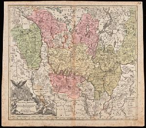
Lotter, Georg Friedrich and Lotter, Tobias Conrad, 1717-1777
Published / Created
ca. 1757
Call Number
1973 Folio 30
Format
Digital Collection / Online / Cartographic
Found In
Access
Public

Creator
Zuerner, Adam Friedrich, 1680-1742
Container / Volume
BRBL_00680
Published / Created
[1709?]
Call Number
11 1709
Format
Digital Collection / Online / Cartographic / Maps & GIS
Found In
Access
Public

Creator
Du Halde, J.-B. (Jean-Baptiste), 1674-1743, Hase, Johann Matthias, 1684-1742, and Homann Erben (Firm)
Published / Created
[1750?]
Call Number
1975 Folio 31
Format
Digital Collection / Online / Cartographic
Found In
Access
Public

Creator
Hase, Johann Matthias, 1684-1742, cartographer.
Published / Created
1739
Call Number
1975 Folio 31
Format
Digital Collection / Online / Cartographic / Maps & GIS
Found In
Beinecke Rare Book and Manuscript Library > Imperii Russici et Tatariae universae tam majoris et Asiaticae, qvam minoris et Europaeae tabvla / ex recentissimis et probatissimis monumentis et relationibus concin[n]ata, et ad legitimas projectionum geographic. regulas plane exacta opera Ioh Matthiae Hasii, Math. P.P. ... ; R.A. Schneider, sc.
Access
Public
Creator
Hase, Johann Matthias, 1684-1742, cartographer. http://id.loc.gov/authorities/names/n85044571
Published / Created
1739
Call Number
1973 Folio 30
Format
Digital Collection / Online / Cartographic / Maps & GIS
Found In
Beinecke Rare Book and Manuscript Library > Imperii Russici et Tatariae universae tam majoris et Asiaticae, qvam minoris et Europaeae tabvla / ex recentissimis et probatissimis monumentis et relationibus concin[n]ata, et ad legitimas projectionum geographic. regulas plane exacta opera Ioh Matthiae Hasii, Math. P.P. ... ; R.A. Schneider, sc.
Access
Public
Creator
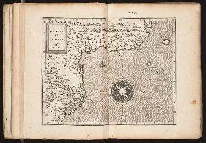
Ptolemy, active 2nd century.
Published / Created
[1599]
Call Number
Gfp94 gi561e
Format
Digital Collection / Online / Cartographic / Maps & GIS
Found In
Beinecke Rare Book and Manuscript Library > Geografia di Claudio Tolomeo Alessandrino [cartographic material] / tradotta di Greco nell'idioma volgare Italiano da Girolamo Ruscelli, et hora nuouamente ampliata da Gioseffo Rosaccio, con varie annotationi, & espositioni, & tauole di rame, che nelli stampati altre volte non erano, hauendo etiando poste à i lor luoghi le tauole vecchie, che prima confusamente giaceuano, et vna Geografia vniuersale del medesimo, separata da quella di Tolomeo; nella quale secondo il parere de' più moderni geografi, fedelmente sono poste le prouincie, regni, città, castelli, monti, fiumi, laghi, porti, golfi, isole, penisole, popoli, leggi, riti, & costumi di ciascuna città. Et vna breue descrittione di tutta la terra, distinta in quattro libri, nel primo de' quali si tratta dell'Europa; nel secondo dell'Africa; nel terza dell'Asia, nel quarto dell'America. Con due indici copiosissimi di tutto quello, che di notabile si contiene nell'opera.
Access
Public

Creator
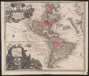
Seutter, Matthaeus, 1678-1756
Published / Created
[approximately 1740?]
Call Number
BrSides Double Folio 2019 21
Format
Digital Collection / Online / Cartographic / Maps & GIS
Found In
Access
Public
Publisher
Opera et sumptibus M. Seütteri, Chalcogr

Container / Volume
BRBL_00234
Description
"Per l'opera Il fiore di Venezia, editore Tommaso Fontana, 1838".
Call Number
403 1838
Format
Digital Collection / Online / Cartographic / Maps & GIS
Found In
Access
Public
