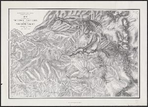
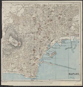
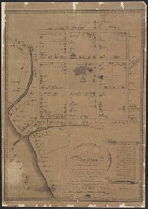
- No49
Container / Volume
BRBL_00073
Published / Created
[1895?]
Call Number
327 1895
Format
Digital Collection / Online / Cartographic / Maps & GIS
Found In
Access
Public
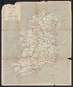
Creator
Automobile Blue Books, Inc
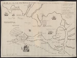
Container / Volume
BRBL_00419
Description
blue books." Includes index to adjoining sheets. Map of the Mid-Atlantic states includes inset
Published / Created
[1921?]
Call Number
754gmb 1920
Format
Digital Collection / Online / Cartographic / Maps & GIS
Found In
Access
Public
Alternative Title
Automobile blue book.
Publisher
Automobile Blue Books,
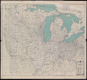
Creator
Weller, Edward
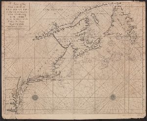
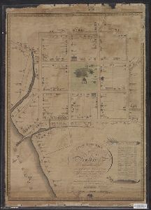
Container / Volume
BRBL_00276
Published / Created
[1871]
Call Number
501 1885
Format
Digital Collection / Online / Cartographic / Maps & GIS
Found In
Access
Public
Creator
League of American Wheelmen. New York State Division
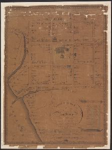
Container / Volume
BRBL_00494
Published / Created
c1893.
Call Number
771gmb 1893
Format
Digital Collection / Online / Cartographic / Maps & GIS
Found In
Access
Public

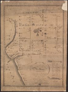
Container / Volume
BRBL_00314
Published / Created
1909
Call Number
583 1909
Format
Digital Collection / Online / Cartographic / Maps & GIS
Found In
Access
Public

Creator
Torrey, Jason, 1772-1848
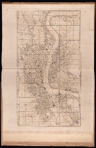
Container / Volume
BRBL_00501
Description
of Pennsylvania." Accompanied by text/index book: An index to the map of Wayne and Pike counties, Pennsylvania
Published / Created
1814
Call Number
774fb W367 1814A
Format
Digital Collection / Online / Cartographic / Maps & GIS
Found In
Access
Public

Creator
Pine, John, 1690-1756, Rocque, John, d. 1762, and Tinney, John
Published / Created
1746
Call Number
2002 Folio 94
Format
Digital Collection / Online / Cartographic / Maps & GIS
Found In
Access
Public
Creator
Geological Survey of California
Container / Volume
BRBL_00615
Published / Created
1989
Call Number
844gcr Si17 1867
Format
Digital Collection / Online / Cartographic / Maps & GIS
Found In
Access
Public
Publisher
Great West Books,
Subject (Name)
Bien, Julius, 1826-1909, Gardner, J. T, Great West Books (Firm), Hoffmann, C. F. (Charles Frederick), 1838-1913, and Whitney, J. D. (Josiah Dwight), 1819-1896
Container / Volume
BRBL_00189
Published / Created
[17--?]
Call Number
39 C11 1702
Format
Digital Collection / Online / Cartographic / Maps & GIS
Found In
Access
Public
Publisher
Sold by David Mortier, book seller,
Creator
W. Mount and T. Page
Container / Volume
BRBL_00688
Description
According to Kershaw this map is the second state. From: The English pilot, the fourth book
Published / Created
[between 1732 and 1749]
Call Number
71cea 1723
Format
Digital Collection / Online / Cartographic / Maps & GIS
Found In
Access
Public
Alternative Title
English pilot. The fourth book.
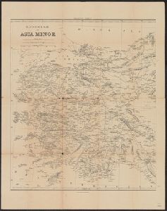
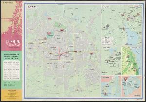
Container / Volume
BRBL_00251
Description
From Hand-book.
Published / Created
[1910?]
Call Number
434 P88 1910A
Format
Digital Collection / Online / Cartographic / Maps & GIS
Access
Public

Creator
Di tu chu ban she
Container / Volume
BRBL_00296
Published / Created
[1982]
Call Number
56 K962 1982
Format
Digital Collection / Online / Cartographic / Maps & GIS
Access
Public
Publisher
Cartographic Pub. House : and Distributed by China International Book Trading Corp.,
Container / Volume
BRBL_00212
Description
From Griebens Guide Book.
Published / Created
[1910?]
Call Number
40 N16 1910
Format
Digital Collection / Online / Cartographic / Maps & GIS
Access
Public
Creator
Willmer & Rogers News Company
Container / Volume
BRBL_00269
Published / Created
[1854]
Call Number
491 1853A
Format
Digital Collection / Online / Cartographic / Maps & GIS
Found In
Access
Public
Publisher
Published by Willmer & Rogers, Importers of Foreign Books & Newspapers, 42 & 44 Nassau Street,
Creator
Willmer & Rogers News Company
Container / Volume
BRBL_00287
Published / Created
[1854]
Call Number
53hc 1878
Format
Digital Collection / Online / Cartographic / Maps & GIS
Found In
Access
Public
Publisher
Published by Willmer & Rogers, Importers of Foreign Books & Newspapers, 42 & 44 Nassau Street,
Container / Volume
BRBL_00219
Description
"From Hand-book" on catalog card.
Published / Created
1910]
Call Number
40 R66 1910
Format
Digital Collection / Online / Cartographic / Maps & GIS
Found In
Access
Public

Container / Volume
BRBL_00451
Description
Osgood's Wihte (sic) Mountain Guide book.
Published / Created
[1880?].
Call Number
762 W588 1880
Format
Digital Collection / Online / Cartographic / Maps & GIS
Found In
Access
Public
Creator
Alʹftan, gvardeĭskīĭ kapitan
Container / Volume
BRBL_00099
Description
In Russian. Inset: Helsinki. Joel Sumner Smith "Catalogue of Books" No. 578.
Published / Created
1860
Call Number
348 1860
Format
Digital Collection / Online / Cartographic / Maps & GIS
Access
Public

Container / Volume
BRBL_00469A
Description
Original MS map from which this was taken is in the Rare Book Room. First copy now on exhibition
Published / Created
[1806?]
Call Number
766 N46 1748
Format
Digital Collection / Online / Cartographic / Maps & GIS
Found In
Access
Public
Container / Volume
BRBL_00469A
Description
Original MS map from wich this was taken is in the Rare Book Room. First copy now on exhibition
Published / Created
[1806?]
Call Number
766 N46 1748
Format
Digital Collection / Online / Cartographic / Maps & GIS
Found In
Access
Public
Container / Volume
BRBL_00469A
Description
Original MS map from wich this was taken is in the Rare Book Room. First copy now on exhibition
Published / Created
[1806?]
Call Number
766 N46 1748
Format
Digital Collection / Online / Cartographic / Maps & GIS
Found In
Access
Public
Container / Volume
BRBL_00469A
Description
Original MS map from wich this was taken is in the Rare Book Room. First copy now on exhibition
Published / Created
[1806?]
Call Number
766 N46 1748
Format
Digital Collection / Online / Cartographic / Maps & GIS
Found In
Access
Public
Creator
Gaudy, John
Container / Volume
BRBL_00372
Description
Appears in The English Pilot, the fourth book. Depths shown by soundings. Includes inset of "A
Published / Created
1715?]
Call Number
72 1715
Format
Digital Collection / Online / Cartographic / Maps & GIS
Found In
Access
Public

Container / Volume
BRBL_00446
Description
From the English Pilot, the Fourth Book, London, W.&I. Mount, T. Page, 1764 and later editions
Published / Created
[1764?]
Call Number
76cea 1764
Format
Digital Collection / Online / Cartographic / Maps & GIS
Found In
Access
Public

Container / Volume
BRBL_00640
Description
From the English Pilot, The Fourth Book, Dublin, George Grierson, 1749 and later and possibly
Published / Created
[1749?]
Call Number
853 1749
Format
Digital Collection / Online / Cartographic / Maps & GIS
Found In
Access
Public
