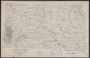
- No29
Container / Volume
BRBL_00375A
Description
In upper margin, left to right: Physical, Atlas of Canada. Relief shown by gradient tints. Depths
Published / Created
191-?]
Call Number
73cbf 1912
Format
Digital Collection / Online / Cartographic / Maps & GIS
Access
Public

Container / Volume
BRBL_00296
Published / Created
[1906?]
Call Number
56 1906
Format
Digital Collection / Online / Cartographic / Maps & GIS
Found In
Access
Public
Container / Volume
BRBL_00171
Published / Created
1828
Call Number
38GMD 1828
Format
Digital Collection / Online / Cartographic / Maps & GIS
Found In
Access
Public

Creator
Petsch, Bruno C. (Bruno Carl), 1901-
Container / Volume
BRBL_00569
Published / Created
[1947]
Call Number
823c 1947
Format
Digital Collection / Online / Cartographic / Maps & GIS
Found In
Access
Public
Container / Volume
BRBL_00662
Published / Created
1811
Call Number
90 1819
Format
Digital Collection / Online / Cartographic / Maps & GIS
Found In
Access
Public

Creator
Benitz, A.
Published / Created
[1840]
Call Number
1973 Folio 105
Format
Digital Collection / Online / Cartographic / Maps & GIS
Found In
Access
Public
Subject (Topic)
Physical geography --Venezuela

Creator
Benitz, A.
Published / Created
[1840]
Call Number
1973 Folio 105
Format
Digital Collection / Online / Cartographic / Maps & GIS
Found In
Access
Public
Subject (Topic)
Physical geography --Venezuela

Creator
Benitz, A.
, Fernandez, Carmelo., and Laplante, Edard de
Published / Created
[1840]
Call Number
1973 Folio 105
Format
Digital Collection / Online / Text / Maps & GIS
Access
Public
Subject (Topic)
Physical geography --Venezuela

Creator
Benitz, A.
Published / Created
[1840]
Call Number
1973 Folio 105
Format
Digital Collection / Online / Cartographic / Maps & GIS
Found In
Access
Public
Subject (Topic)
Physical geography --Venezuela

Creator
Benitz, A.
Published / Created
[1840]
Call Number
1973 Folio 105
Format
Digital Collection / Online / Cartographic / Maps & GIS
Found In
Access
Public
Subject (Topic)
Physical geography --Venezuela

Creator
Benitz, A.
Published / Created
[1840]
Call Number
1973 Folio 105
Format
Digital Collection / Online / Cartographic / Maps & GIS
Access
Public
Subject (Topic)
Physical geography --Venezuela

Creator
American Geographical Society of New York
Container / Volume
BRBL_00010T
Published / Created
[1918]
Call Number
11hcf 1919C-2
Format
Digital Collection / Online / Cartographic / Maps & GIS
Found In
Access
Public
Subject (Topic)
Slopes (Physical geography)--Balkan Peninsula--Maps

Creator
American Geographical Society of New York
Container / Volume
BRBL_00256
Published / Created
1918
Call Number
44cbd 1918
Format
Digital Collection / Online / Cartographic / Maps & GIS
Found In
Access
Public
Subject (Topic)
Slopes (Physical geography)--Balkan Peninsula--Maps

Creator
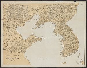
Columbia University. Geographical Press and Lobeck, A. K. (Armin Kohl), 1886-1958
Container / Volume
BRBL_00037A
Published / Created
c1923, repr. 1944.
Call Number
30cbd 1923
Format
Digital Collection / Online / Cartographic / Maps & GIS
Found In
Access
Public
Subject (Topic)
Geomorphology--Europe--Maps and Physical geography--Europe--Maps

Creator
Benitz, A.
Published / Created
[1840]
Call Number
1973 Folio 105
Format
Digital Collection / Online / Cartographic / Maps & GIS
Found In
Access
Public
Subject (Topic)
Mountains --Venezuela, Physical geography --Venezuela, and Rivers --Venezuela

Creator
Harrison, Richard Edes
Container / Volume
BRBL_00329
Description
, German colonies, Islam. Physical geography -- Political complexion. Published in Fortune, Nov. 1941
Published / Created
1941
Call Number
60C 1941
Format
Digital Collection / Online / Cartographic / Maps & GIS
Access
Public
Subject (Topic)
Administrative and political divisions--Africa--Maps and Physical geography--Africa--Maps

Creator
Raisz, Erwin, 1893-1968
Container / Volume
BRBL_00537
Published / Created
c1941.
Call Number
80cb 1941A
Format
Digital Collection / Online / Cartographic / Maps & GIS
Found In
Access
Public
Subject (Topic)
Landforms--Northwest, Pacific--Maps and Physical geography--Northwest, Pacific--Maps

Creator
Waddell, J. H. (John Hunter)
Container / Volume
BRBL_00410
Published / Created
1868
Call Number
75GBC 1868
Format
Digital Collection / Online / Cartographic / Maps & GIS
Found In
Access
Public
Publisher
Office of Physical Survey of Virginia Virginia Military Institute,

Creator
Waddell, J. H
Container / Volume
BRBL_00404
Published / Created
1868?]
Call Number
75 1868
Format
Digital Collection / Online / Cartographic / Maps & GIS
Found In
Access
Public
Publisher
Office of Physical Survey of Virginia? Virginia Military Institute,

Creator
Maryland Geological Survey
Container / Volume
BRBL_00504A
Published / Created
1900
Call Number
777fb Al53 1900
Format
Digital Collection / Online / Cartographic / Maps & GIS
Found In
Access
Public
Alternative Title
Allegany County Atlas and Physical atlas of Maryland.

Creator
Kartograficheskoe zavedenīe A. Ilʹina
Container / Volume
BRBL_00102
Description
Map on recto shows physical features. Map on verso shows administrative divisions.
Published / Created
[1885?]
Call Number
35cbf 1885
Format
Digital Collection / Online / Cartographic / Maps & GIS
Access
Public

Creator
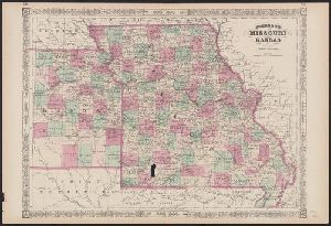
Johnson, A. J. (Alvin Jewett), 1827-1884
Container / Volume
BRBL_00561
Published / Created
1866]
Call Number
816 1866
Format
Digital Collection / Online / Cartographic / Maps & GIS
Access
Public
Alternative Title
Johnson's new illustrated family atlas of the world, with physical geography, and with descriptions and Missouri and Kansas
Creator
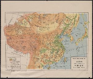
United States. Office of Naval Intelligence
Container / Volume
BRBL_00292
Description
to the Russian border and south to the northern tip of Japan. Physical map not showing military operations
Published / Created
[191-?]
Call Number
556 1895
Format
Digital Collection / Online / Cartographic / Maps & GIS
Found In
Access
Public
Creator
Arrowsmith, John, 1790-1873
Container / Volume
BRBL_00379
Description
atlas of universal geography, exhibiting the physical & political divisions of the various countries
Published / Created
1838
Call Number
734 1834
Format
Digital Collection / Online / Cartographic / Maps & GIS
Found In
Access
Public

Creator
Matthews-Northrup Works
Container / Volume
BRBL_00646
Description
," "Physical map of Mexico," and "Central portion of Mexico, on twice the scale of the main map." Supplement
Published / Created
c1916.
Call Number
88 1916
Format
Digital Collection / Online / Cartographic / Maps & GIS
Found In
Access
Public
