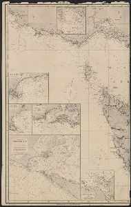
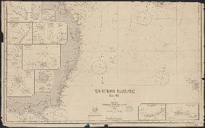
Container / Volume
BRBL_00022
Published / Created
[1900?]
Call Number
26 1900
Format
Digital Collection / Online / Cartographic / Maps & GIS
Access
Public
Subject (Topic)
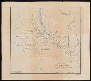
Cables, Submarine--Australia--Maps and Railroads--Australia--Maps

Creator
Huntington, Ellsworth, 1876-1947
Container / Volume
Box 66, folder 2376
Published / Created
1931
Call Number
MS 1
Format
Digital Collection / Online
Found In
Access
Public

Creator
Huntington, Ellsworth, 1876-1947
Container / Volume
Box 59, folder 2060
Published / Created
1928
Call Number
MS 1
Format
Digital Collection / Online
Found In
Access
Public

Creator
Huntington, Ellsworth, 1876-1947
Container / Volume
Box 53, folder 1740
Published / Created
1926
Call Number
MS 1
Format
Digital Collection / Online
Found In
Access
Public

Creator
Huntington, Ellsworth, 1876-1947
Container / Volume
Box 50, folder 1590
Published / Created
1925
Call Number
MS 1
Format
Digital Collection / Online
Found In
Access
Public

Creator
Huntington, Ellsworth, 1876-1947
Container / Volume
Box 46, folder 1347
Published / Created
1923
Call Number
MS 1
Format
Digital Collection / Online
Found In
Access
Public

Creator
Gould, John, 1804-1881
Published / Created
1848.
Call Number
SSy13 A8 848G 2
Format
Digital Collection / Online
Access
Public
Subject (Name)
Birds Australia.

Creator
Huntington, Ellsworth, 1876-1947
Container / Volume
Box 43, folder 1208
Published / Created
1921
Call Number
MS 1
Format
Digital Collection / Online
Found In
Access
Public

Creator
Huntington, Ellsworth, 1876-1947
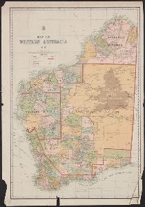
Container / Volume
Box 41, folder 1109
Published / Created
1920
Call Number
MS 1
Format
Digital Collection / Online
Found In
Access
Public

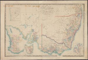
Creator
Western Australia. Department of Lands and Surveys
Container / Volume
BRBL_00023
Published / Created
1913
Call Number
2651 1913
Format
Digital Collection / Online / Cartographic / Maps & GIS
Access
Public

Creator
Nadezhin, Nikolai Alexandrovich, 1885-1959
Container / Volume
Box 1, folder 21
Published / Created
1930 Jun 14
Call Number
GEN MSS 99
Format
Digital Collection / Online
Found In
Access
Public

Creator
Geological Survey of South Australia
Container / Volume
BRBL_00023
Description
L. Keith Ward, Government Geologist. Zoning map of South Australia showing physiography
Published / Created
1917
Call Number
265cbf 1917
Format
Digital Collection / Online / Cartographic / Maps & GIS
Access
Public
Subject (Topic)
Geomorphology--Australia--South Australia--Maps

Creator
Western Australia. Department of Lands and Surveys and Western Australia. Government Statistician's Office. Statistical register of Western Australia
Container / Volume
BRBL_00023
Description
of Western Australia for 1900 in Part V, facing p. 2.
Published / Created
1900
Call Number
2651fbd 1900
Format
Digital Collection / Online / Cartographic / Maps & GIS
Access
Public
Subject (Topic)
Election districts--Western Australia--Maps

Creator
Hulme, Kathryn, 1900-1981
Container / Volume
Box 47, folder 660
Published / Created
1873-1974
Call Number
YCAL MSS 22
Format
Digital Collection / Online
Found In
Access
Public

Container / Volume
BRBL_00023A
Published / Created
1945?]
Call Number
26cbf 1945A
Format
Digital Collection / Online / Cartographic / Maps & GIS
Access
Public

Container / Volume
BRBL_00023A
Published / Created
1945?]
Call Number
26cbf 1945D
Format
Digital Collection / Online / Cartographic / Maps & GIS
Access
Public

Creator
Beinecke, Edwin J. (Edwin John), 1886-1970
Container / Volume
Box 52, folder 1130
Published / Created
1893 March 12
Call Number
GEN MSS 664
Format
Digital Collection / Online
Found In
Access
Public

Container / Volume
BRBL_00707
Published / Created
[1870?]
Call Number
556 1870
Format
Digital Collection / Online / Cartographic / Maps & GIS
Access
Public

Creator
H. Alt & Schröder, engravers, Justus Perthes (Firm : Gotha, Germany), publisher, Petermann, A. (August Heinrich), 1822-1878, and Stieler, Adolf, 1775-1836. Stieler's Hand-Atlas
Container / Volume
BRBL_00022
Description
In German. In lower left margin: Rev. 1883. Map of Australia showing explorers' tracks, railways
Published / Created
[1883?]
Call Number
26 1883
Format
Digital Collection / Online / Cartographic / Maps & GIS
Found In
Access
Public
Subject (Topic)
Railroads--Australia--Maps

Creator
H. Alt & Schröder, engravers, Justus Perthes (Firm : Gotha, Germany), publisher, Petermann, A. (August Heinrich), 1822-1878, and Stieler, Adolf, 1775-1836. Stieler's Hand-Atlas
Container / Volume
BRBL_00022
Description
Imperfect In German. In lower right margin: Gestochen von H. Alt & Schröder. Map of Australia
Published / Created
[1873?]
Call Number
26 1873
Format
Digital Collection / Online / Cartographic / Maps & GIS
Access
Public
Subject (Topic)
Railroads--Australia--Maps

Creator
Arrowsmith, John, 1790-1873
Container / Volume
BRBL_00022
Description
Map of eastern Australia (east of 130 ̊long.), considerably more detailed than his 1842 version
Published / Created
1st Jany. 1850.
Call Number
26 1850B
Format
Digital Collection / Online / Cartographic / Maps & GIS
Found In
Access
Public
Subject (Topic)
Counties--Australia, Eastern--Maps

Creator
Arrowsmith, John, 1790-1873, cartographer
Description
From John Lort Stokes's Discoveries in Australia (1846). Includes index of counties and notes
Published / Created
Apl. 1st 1846.
Call Number
BrSides 2019 93
Format
Digital Collection / Online / Cartographic / Maps & GIS
Found In
Access
Public
Subject (Name)
Beagle Expedition--(1831-1836)--Maps. and Stokes, John Lort, 1811-1885. Discoveries in Australia.
Subject (Topic)
Counties--Australia--New South Wales--Maps., Counties--Australia--Western Australia--Maps., and Discoveries in geography

Creator
McAdoo, Orpheus M. (Orpheus Myron), 1858-1900
Container / Volume
Box 3, folder 22
Published / Created
1886-1888
Call Number
JWJ MSS 60
Format
Digital Collection / Online
Found In
Access
Public

Creator
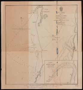
South Australia. Hydraulic Engineer's Dept
Container / Volume
BRBL_00023
Published / Created
1916 [i.e. 1917?]
Call Number
265 Ad32 1916
Format
Digital Collection / Online / Cartographic / Maps & GIS
Found In
Access
Public
Subject (Topic)
Real property--Australia--Adelaide (S. Aust.)--Maps

Creator
Kissinger, Henry, 1923-2023
Container / Volume
Box 703, folder 25
Published / Created
1985-1986
Call Number
MS 1981
Format
Digital Collection / Online
Found In
Access
Public

Creator
Geological Survey of South Australia
Container / Volume
BRBL_00023
Published / Created
[1921?]
Call Number
265gbc 1921
Format
Digital Collection / Online / Cartographic / Maps & GIS
Found In
Access
Public
Subject (Topic)
Mines and mineral resources--Australia--South Australia--Maps

Creator
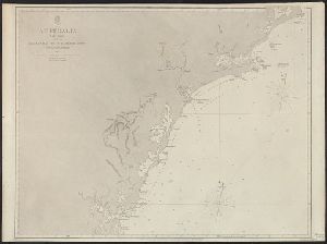
Imray, James F. (James Frederick), 1829?-1891, author and James Imray and Son, publisher
Container / Volume
BRBL_00021
Call Number
23cea 1884
Format
Digital Collection / Online / Cartographic / Maps & GIS
Found In
Access
Public
Subject (Topic)
Nautical charts--Australia, Southeastern
Creator
H.G. De Gruchy and Company
Published / Created
[between 1860 and 1880]
Call Number
266 1860
Format
Digital Collection / Online / Cartographic / Maps & GIS
Found In
Access
Public
Subject (Topic)
Counties--Australia--Tasmania--Maps.

Container / Volume
Box 10
Published / Created
1900-1930
Format
Digital Collection / Online / Images
Access
Public

Abstract
The First Map of Australia, from Nicholas Vallard's Atlas, 1547, in the Library of Sir Thomas
Container / Volume
Box 18
Published / Created
1547
Call Number
1976 Folio 80
Format
Digital Collection / Online / Cartographic / Maps & GIS
Found In
Access
Public
Creator
James Imray and Son
Container / Volume
BRBL_00021
Published / Created
1864
Call Number
23cea 1864
Format
Digital Collection / Online / Cartographic / Maps & GIS
Found In
Access
Public

Creator
Western Australia. Department of Lands and Surveys
Container / Volume
BRBL_00023
Published / Created
1904
Call Number
2651 1904
Format
Digital Collection / Online / Cartographic / Maps & GIS
Found In
Access
Public
Subject (Topic)
Land use, Rural--Australia--Western Australia--Maps

Creator
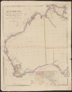
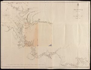
Victoria. Immigration and Labor Bureau
Container / Volume
BRBL_00023
Description
Includes inset of Australia showing population figures for each territory, and statistical tables
Published / Created
1914
Call Number
263gme 1914
Format
Digital Collection / Online / Cartographic / Maps & GIS
Found In
Access
Public
Subject (Topic)
Agriculture--Australia--Victoria--Maps, Irrigation--Australia--Victoria--Maps, Mines and mineral resources--Australia--Victoria--Maps, Railroads--Australia--Victoria--Maps, and Rain and rainfall--Australia--Victoria

Creator
Western Australia. Department of Lands and Surveys
Container / Volume
BRBL_00023
Description
Insets: World; Australia; Perth and vicinity.
Published / Created
1903
Call Number
2651 1903
Format
Digital Collection / Online / Cartographic / Maps & GIS
Found In
Access
Public

Creator
Western Australia. Department of Lands and Surveys
Container / Volume
BRBL_00023
Published / Created
1905
Call Number
2651 1905
Format
Digital Collection / Online / Cartographic / Maps & GIS
Found In
Access
Public
Creator
Talbot, H. W. B
Container / Volume
BRBL_00023
Published / Created
1911
Call Number
2651gfc M47 1911
Format
Digital Collection / Online / Cartographic / Maps & GIS
Access
Public
Publisher
Geological Survey of Western Australia,
Subject (Name)
Geological Survey of Western Australia
Subject (Topic)
Geology--Australia--Meekatharra (W.A.)--Maps

Creator
Kissinger, Henry, 1923-2023
Container / Volume
Box 692, folder 12
Published / Created
1978-1979
Call Number
MS 1981
Format
Digital Collection / Online
Found In
Access
Public
Container / Volume
Box 10
Description
and contains a printed title: "Missioni dei Cappuccinni - Australia." ("Missions of the Cappuccini - Australia.")
Published / Created
1900-1930
Format
Digital Collection / Online / Images
Access
Public

Container / Volume
Box 395
Call Number
RG 11
Format
Digital Collection / Online / Images
Found In
Access
Public

Creator
South Australia. Office of the Surveyor General
Container / Volume
BRBL_00023
Published / Created
[1910?]
Call Number
265 1910
Format
Digital Collection / Online / Cartographic / Maps & GIS
Found In
Access
Public

Creator
James Lumsden & Son, Johnston, Alexander Keith, 1804-1871, and W. & A.K. Johnston Limited
Container / Volume
BRBL_00022
Published / Created
1853
Call Number
26 1853
Format
Digital Collection / Online / Cartographic / Maps & GIS
Found In
Access
Public

Container / Volume
Box 13 | Folder 147
Description
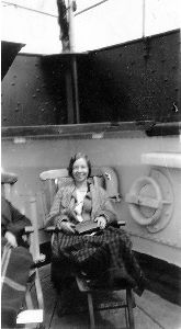
" Armfield off for Australia." Three Western women in dresses stand on the deck of a ship, with a lifeboat
Published / Created
1930-1940
Format
Digital Collection / Online / Images
Found In
Access
Public

Call Number
1994 156
Format
Digital Collection / Online / Images
Found In
Access
Public

Creator
Arrowsmith, John, 1790-1873, cartographer
Description
) in Western Australia, showing coastal soundings and topography of an area of approx. 250 square miles inland
Published / Created
1846
Call Number
BrSides 2019 95
Format
Digital Collection / Online / Cartographic / Maps & GIS
Found In
Access
Public
Subject (Name)
Beagle (Ship), Grey, George,--1812-1898, Grey, George,--1812-1898--Travel--Australia--Western Australia--Maps., Stokes, John Lort, 1811-1885. Discoveries in Australia., and Stokes, John Lort,--1811-1885--Travel--Australia--Western Australia--Maps.
Subject (Topic)
Discoveries in geography, Nautical charts--Australia--Champion Bay (W.A.), and Voyages and travels
Published / Created
2005
Call Number
RU 342
Format
Digital Collection / Online / Images
Found In
Access
Public

Container / Volume
Box 407 | Folder 5829
Published / Created
1931 June
Call Number
RG 11
Format
Digital Collection / Online / Images
Found In
Access
Public
Creator
Great Britain. Admiralty
Container / Volume
BRBL_00022
Published / Created
1894 [i.e. 1903?]
Call Number
261cea T636 1894
Format
Digital Collection / Online / Cartographic / Maps & GIS
Found In
Access
Public

Creator
Anglo-Australian & China Telegraph Company, Limited
Published / Created
1863
Call Number
BrSides Folio 2019 3
Format
Digital Collection / Online / Cartographic / Maps & GIS
Found In
Access
Public
Alternative Title
General map of telegraph lines between England and Australia
Published / Created
2005
Call Number
RU 342
Format
Digital Collection / Online / Images
Found In
Access
Public
Creator
Canning, Alfred Wernam, 1860-1936
Container / Volume
BRBL_00023
Published / Created
1911
Call Number
2651 W713 1911
Format
Digital Collection / Online / Cartographic / Maps & GIS
Found In
Access
Public
Subject (Topic)
Stock routes--Western Australia--Maps

Creator
Haack, Hermann, 1872-1966, cartographer
Container / Volume
BRBL_00022
Published / Created
1902
Call Number
26 1902A
Format
Digital Collection / Online / Cartographic / Maps & GIS
Found In
Access
Public
Alternative Title
Commonwealth of Australia :

Creator
Huntington, Ellsworth, 1876-1947
Container / Volume
Box 11
Published / Created
Early 1900s
Call Number
MS 1
Format
Digital Collection / Online
Found In
Access
Public

Container / Volume
BRBL_00022
Published / Created
[18--]
Call Number
26 1860
Format
Digital Collection / Online / Cartographic / Maps & GIS
Found In
Access
Public
Alternative Title
Karte v. Festland Australia and Karte v[on] Festland Australia

Creator
Great Britain. Hydrographic Department, cartographer
Description
Stokes's Discoveries in Australia (1846). Imperfect: mutilated. Inset Nautical chart of Port Adelaide
Published / Created
March 23rd 1846.
Call Number
BrSides 2019 97
Format
Digital Collection / Online / Cartographic / Maps & GIS
Found In
Access
Public
Subject (Name)
Bate, R. B. (Robert Brettell), bookseller, J. & C. Walker (Firm), engraver, and Stokes, John Lort, 1811-1885. Discoveries in Australia.
Subject (Topic)
Nautical charts--Australia--Holdfast Bay (S.A. : Bay) and Nautical charts--Australia--Port Adelaide Region (S.A.)
Creator
Great Britain. Hydrographic Dept and Stokes, J. Lort (John Lort), 1811-1885
Container / Volume
BRBL_00023
Published / Created
Aug. 16th. 1852 [i.e. 1865]
Call Number
26cea 1851A
Format
Digital Collection / Online / Cartographic / Maps & GIS
Found In
Access
Public

Creator
Great Britain. Hydrographic Dept and Potter, J. D
Container / Volume
BRBL_00023
Published / Created
Aug. 16th 1852 [i.e. 1865]
Call Number
26cea 1851C
Format
Digital Collection / Online / Cartographic / Maps & GIS
Found In
Access
Public

Creator
Great Britain. Hydrographic Department, author
Container / Volume
BRBL_00021
Call Number
254cea 1886
Format
Digital Collection / Online / Cartographic / Maps & GIS
Found In
Access
Public

Creator
Wyld, James, 1812-1887
Container / Volume
BRBL_00022
Description
on linen. Sheet measures 68 x 101 cm. Map of southern Australia with notes on the topography and gold
Published / Created
[1853]
Call Number
26 1852
Format
Digital Collection / Online / Cartographic / Maps & GIS
Found In
Access
Public
Container / Volume
Box 108 | Slide: 80
Published / Created
1936 {id=286414}
Call Number
GEN MSS 475
Format
Digital Collection / Online / Text
Found In
Access
Public

Creator
Arrowsmith, John, 1790-1873
Container / Volume
BRBL_00022
Published / Created
1st. Jany. 1850.
Call Number
26 1850A
Format
Digital Collection / Online / Cartographic / Maps & GIS
Found In
Access
Public
Creator
Stokes, John Lort, 1811-1885, cartographer
Description
At foot of page: J. Arrowsmith. From John Lort Stokes's Discoveries in Australia (1846).
Published / Created
1846
Call Number
BrSides 2019 98
Format
Digital Collection / Online / Cartographic / Maps & GIS
Found In
Access
Public
Subject (Name)
Arrowsmith, John, 1790-1873 and Stokes, John Lort, 1811-1885. Discoveries in Australia.

Container / Volume
BRBL_00022
Published / Created
1847
Call Number
26 1847
Format
Digital Collection / Online / Cartographic / Maps & GIS
Found In
Access
Public

Creator
Great Britain. Hydrographic Dept and Stokes, J. Lort (John Lort), 1811-1885
Container / Volume
BRBL_00023
Published / Created
Aug. 16th. 1852 [i.e. 1865]
Call Number
26cea 1851B
Format
Digital Collection / Online / Cartographic / Maps & GIS
Found In
Access
Public

Creator
Great Britain. Hydrographic Dept and Potter, J. D
Container / Volume
BRBL_00023
Published / Created
Aug. 16th. 1852 [i.e. 1862]
Call Number
26cea 1851D
Format
Digital Collection / Online / Cartographic / Maps & GIS
Found In
Access
Public
Creator
New South Wales. Department of Lands
Description
of Australia, 1911, by the Authority of the Hon. King O'Malley, Minister of State for Home Affairs." Inset
Published / Created
1911
Call Number
BrSides Elephant Folio 2018 30
Format
Digital Collection / Online / Cartographic / Maps & GIS
Found In
Access
Public

Container / Volume
BRBL_00294
Published / Created
1883
Call Number
556FD 1883
Format
Digital Collection / Online / Cartographic / Maps & GIS
Found In
Access
Public

Creator
Dayman, J. M, Great Britain. Hydrographic Dept, J. & C. Walker (Firm), Obree, W. H, Potter, J. D. (John D.), Simpson, H. G, Stanley, Owen, 1811-1850, and Yule, C. B
Container / Volume
BRBL_00022
Published / Created
June 1st, 1855 [i.e. 1911?]
Call Number
261cea T636 1855
Format
Digital Collection / Online / Cartographic / Maps & GIS
Found In
Access
Public

Creator
Stokes, John Lort, 1811-1885, cartographer
Description
From John Lort Stokes's Discoveries in Australia (1846). Lower left-hand corner: :Captn Stokes
Published / Created
Feby 18th 1846.
Call Number
BrSides 2019 96
Format
Digital Collection / Online / Cartographic / Maps & GIS
Found In
Access
Public
Subject (Name)
Arrowsmith, John, 1790-1873, publisher, Beagle (Ship), and Stokes, John Lort, 1811-1885. Discoveries in Australia.

Creator
Arrowsmith, John, 1790-1873, cartographer
Description
From John Lort Stokes's Discoveries in Australia (1846). Relief shown by hachures.
Published / Created
1846
Call Number
BrSides 2019 94
Format
Digital Collection / Online / Cartographic / Maps & GIS
Found In
Access
Public
Subject (Name)
Stanley, Owen, surveyor, Stokes, John Lort, 1811-1885. Discoveries in Australia., and Thomas and William Boone, publisher

Container / Volume
BRBL_00023
Published / Created
1855
Call Number
26cea 1843A
Format
Digital Collection / Online / Cartographic / Maps & GIS
Found In
Access
Public

Creator
Evans, F. J. (Frederick J.), Great Britain. Hydrographic Dept, J. & C. Walker (Firm), Potter, J. D. (John D.), and Washington Capt
Container / Volume
BRBL_00023
Published / Created
Decr. 12th 1860.
Call Number
26cea 1860
Format
Digital Collection / Online / Cartographic / Maps & GIS
Found In
Access
Public

Creator
Stokes, John Lort, 1811-1885, cartographer.
Description
At head of title: Australia N.W. Coast. Coordinates not present on map and are approximated
Published / Created
Apr. 5, 1845.
Call Number
BrSides Double Folio 2019 107
Format
Digital Collection / Online / Cartographic / Maps & GIS
Found In
Access
Public
Alternative Title
Australia N.W. coast :
Subject (Topic)
Nautical charts--Australia--Northern Territory.
Container / Volume
BRBL_00023
Published / Created
1855
Call Number
26cea 1843
Format
Digital Collection / Online / Cartographic / Maps & GIS
Found In
Access
Public

Container / Volume
BRBL_00023
Published / Created
1855
Call Number
26cea 1843B
Format
Digital Collection / Online / Cartographic / Maps & GIS
Found In
Access
Public

Creator
Stokes, John Lort, 1811-1885, cartographer.
Description
At head of title: Australia Gulf of Carpentaria. Coordinates not present on map
Published / Created
April 10, 1845.
Call Number
BrSides Double Folio 2019 108
Format
Digital Collection / Online / Cartographic / Maps & GIS
Found In
Access
Public
Alternative Title
Australia Gulf of Carpentaria :
Subject (Topic)
Albert River (Qld.)--Maps., Albert River (Qld.)--Navigation--Maps., and Nautical charts--Australia--Queensland.

Creator
Western Australia. Department of Lands and Surveys
Container / Volume
BRBL_00023
Published / Created
1921
Call Number
2651 R197 1921
Format
Digital Collection / Online / Cartographic / Maps & GIS
Access
Public
Creator
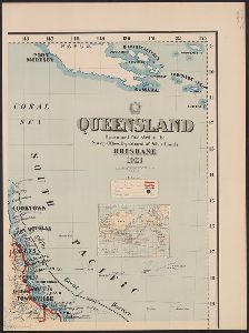
Queensland. Dept. of Public Lands
Container / Volume
BRBL_00022
Description
Inset: The world showing relative position of Australia.
Published / Created
1921
Call Number
261 1921A
Format
Digital Collection / Online / Cartographic / Maps & GIS
Access
Public
Creator
Lees, Steven, 1954-, artist
Published / Created
[1988]
Call Number
Poster0646
Format
Digital Collection / Online / Images
Found In
Access
Yale Community Only
Publisher
Commonwealth Department of Community Services and Health, Aboriginal Health Workers of Australia

Creator
Callaghan, Michael, 1952-2012, artist
Published / Created
[1987]
Call Number
Poster0047
Format
Digital Collection / Online / Images
Found In
Access
Yale Community Only
Publisher
of Australia (Queensland)
Creator
Richards, Thomas, Sharp, G. W, and Tayler, J., fl. 1861-1875
Container / Volume
BRBL_00022
Description
Copies 1-2 affixed to booklet. Inset: Australia. Scale [ca. 1:60 000 000]. On verso: "New South
Published / Created
1876
Call Number
262ca 1876
Format
Digital Collection / Online / Cartographic / Maps & GIS
Found In
Access
Public
Alternative Title
Mineral map and general statistics of New South Wales, Australia and Mineral map and general statistics of New South Wales, Australia.

Container / Volume
BRBL_00272
Description
Includes inset of "New Holland" [i.e. Australia]. On verso: 39. Relief shown pictorially.
Published / Created
[1794?]
Call Number
50 1794
Format
Digital Collection / Online / Cartographic / Maps & GIS
Found In
Access
Public

Creator
Wyld, James, 1812-1887
Container / Volume
BRBL_00620
Description
and Australia" and "British possessions in America." Library's copy 2 dissected and mounted on linen, 50 x 70 cm
Published / Created
April 10th 1845.
Call Number
846 1845
Format
Digital Collection / Online / Cartographic / Maps & GIS
Found In
Access
Public
Alternative Title
British possessions in America. and Map to shew the communication from the N.W. Coast of America to China and Australia

Published / Created
circa 1995-2017
Call Number
VRC 1990a
Format
Digital Collection / Online
Found In
Access
Public

Published / Created
circa 1995-2017
Call Number
VRC 1990a
Format
Digital Collection / Online
Found In
Access
Public

Creator
Goos, Pieter, approximately 1616-1675
Abstract
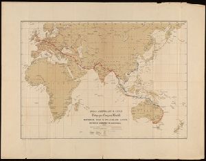
Sea chart of Australia (Hollandia Nova) Southeast Asia, China, Japan, Korea and India. Three Dutch
Call Number
Lanman 27 1666
Format
Digital Collection / Online / Cartographic / Maps & GIS
Found In
Access
Public

Published / Created
circa 1995-2017
Call Number
VRC 1990a
Format
Digital Collection / Online
Found In
Access
Public

Published / Created
circa 1995-2017
Call Number
VRC 1990a
Format
Digital Collection / Online
Found In
Access
Public

Published / Created
circa 1995-2017
Call Number
VRC 1990a
Format
Digital Collection / Online
Found In
Access
Public

Published / Created
circa 1995-2017
Call Number
VRC 1990a
Format
Digital Collection / Online
Found In
Access
Public

Creator
Low, David, 1891-1963
Container / Volume
Box 8, folder 396
Published / Created
1943-47, n.d.
Call Number
GEN MSS 96
Format
Digital Collection / Online
Found In
Access
Yale Community Only
Creator
Kitchin, Thomas, d. 1784
Container / Volume
BRBL_00681
Description
Cross collection no. 43. Map of the world showing wind patterns and incomplete outline of Australia
Published / Created
1760?]
Call Number
11 1755A
Format
Digital Collection / Online / Cartographic / Maps & GIS
Found In
Access
Public

Creator
Bougainville, Louis-Antoine de, comte, 1729-1811
Description
]. Prime meridian: Paris. Watermark. World map showing route of the Boudeuse and the Etoile. Australia
Published / Created
[1771]
Call Number
BrSides Folio 2019 83
Format
Digital Collection / Online / Cartographic / Maps & GIS
Found In
Access
Public

Creator
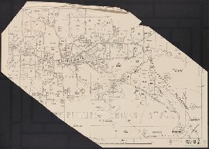
Slight, James and Victoria. Dept. of Crown Lands and Survey
Container / Volume
BRBL_00023
Description
Inset: Map of Australia and adjacent islands. Scale [ca. 1:35,000,000]. Map of Victoria showing
Published / Created
1875
Call Number
263 1875
Format
Digital Collection / Online / Cartographic / Maps & GIS
Found In
Access
Public

Creator
Robert de Vaugondy, Gilles, 1688-1766
Container / Volume
BRBL_00681
Description
of Australia joining Van Diemen's Land to d'Esprit. Title in decorative frame; colour-coded according to major
Published / Created
1761
Call Number
11 1761
Format
Digital Collection / Online / Cartographic / Maps & GIS
Found In
Access
Public

Creator
Geographisches Institut (Weimar, Thuringia, Germany), Kiepert, Heinrich, 1818-1899, and Weiland, C. F. (Carl Ferdinand), -1847, cartographer
Container / Volume
BRBL_00022
Description
Süd-Australia. Prime meridians: Ferro, Greenwich and Paris. Top right-hand corner: "67".
Published / Created
[1855?]
Call Number
26 1855
Format
Digital Collection / Online / Cartographic / Maps & GIS
Found In
Access
Public

Creator
Imray, James F. (James Frederick), 1829?-1891, cartographer and James Imray and Son, issuing body
Container / Volume
BRBL_00021
Description
Hydrographic chart of the western Pacific Ocean, including eastern Australia, Papua New Guinea
Call Number
23cea 1886
Format
Digital Collection / Online / Cartographic / Maps & GIS
Found In
Access
Public
Creator
Robert de Vaugondy, Gilles, 1688-1766.
Container / Volume
BRBL_00023A
Description
-west coast of Australia. From: Atlas universel / par m. Robert geographe et Robert de Vaugondy son fils
Published / Created
[1757-1786?]
Call Number
27 1750
Format
Digital Collection / Online / Cartographic / Maps & GIS
Found In
Access
Public

Creator
Hill, Nathaniel, 1708-1768
Description
pocket globe showing the tracks of Anson's voyage, 1740-1744. Australia is drawn according to the Dutch
Published / Created
1754.
Call Number
Globe 45
Format
Digital Collection / Online / Cartographic Three Dimensional Form
Found In
Access
Public

Creator
Sconall, Tompson, M.D.
Description
that reads "South Australia". Above the scene, in the upper horizontal border, is the motto Omnia Deus Dat.
Format
Digital Collection / Online / Images
Found In
Access
Public
