- No16
Digital Collections Search Results
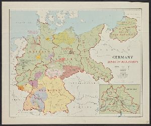
Creator
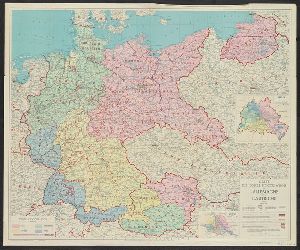
United States. Department of State. Division of Map Intelligence and Cartography
Container / Volume
BRBL_00129
Published / Created
1946
Call Number
36fd 1946
Format
Digital Collection / Online / Cartographic / Maps & GIS
Access
Public
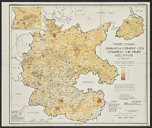
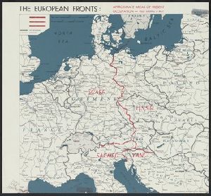
Creator
United States. Office of Strategic Services. Research and Analysis Branch
Container / Volume
BRBL_00127
Published / Created
1945
Call Number
36eb 1939A
Format
Digital Collection / Online / Cartographic / Maps & GIS
Found In
Access
Public
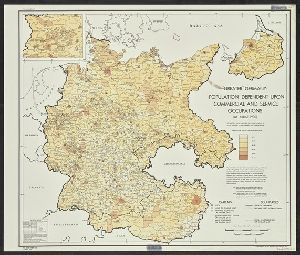
Creator
United States. Office of Strategic Services. Research and Analysis Branch
Container / Volume
BRBL_00127
Published / Created
1945
Call Number
36eb 1939A
Format
Digital Collection / Online / Cartographic / Maps & GIS
Found In
Access
Public
Container / Volume
BRBL_00155
Published / Created
[1947]
Call Number
38 1947
Format
Digital Collection / Online / Cartographic / Maps & GIS
Found In
Access
Public
Container / Volume
BRBL_00601
Published / Created
[1847]
Call Number
844 1847
Format
Digital Collection / Online / Cartographic / Maps & GIS
Found In
Access
Public

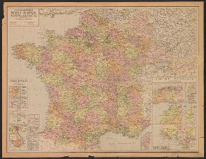
Creator
Institut géographique national (France)
Container / Volume
BRBL_00128
Published / Created
1946
Call Number
36f 1946
Format
Digital Collection / Online / Cartographic / Maps & GIS
Found In
Access
Public
Creator
United States. Office of Strategic Services. Research and Analysis Branch
Container / Volume
BRBL_00010ZG
Published / Created
[1945?]
Call Number
11hd 1945K-3
Format
Digital Collection / Online / Cartographic / Maps & GIS
Found In
Access
Public
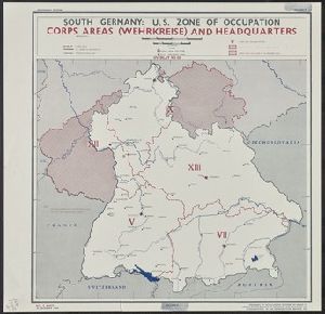
Creator
United States. Office of Strategic Services
Container / Volume
BRBL_00132
Published / Created
1944
Call Number
36ha 1944C
Format
Digital Collection / Online / Cartographic / Maps & GIS
Found In
Access
Public
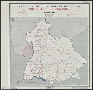
Subject (Topic)
Military occupation--Germany, Southern--Maps
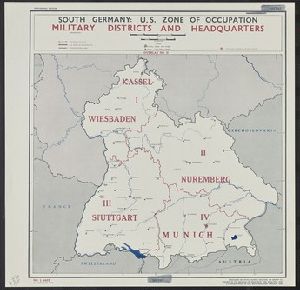
Creator
United States. Office of Strategic Services
Container / Volume
BRBL_00132
Published / Created
1944
Call Number
36ha 1944B
Format
Digital Collection / Online / Cartographic / Maps & GIS
Found In
Access
Public
Subject (Topic)
Military occupation--Germany, Southern--Maps
Creator
United States. Office of Strategic Services. Research and Analysis Branch
Container / Volume
BRBL_00132
Published / Created
1944
Call Number
36ha 1944A
Format
Digital Collection / Online / Cartographic / Maps & GIS
Found In
Access
Public
Subject (Topic)
Military occupation--Germany, Southern--Maps
Container / Volume
BRBL_00010V
Description
Ms. notes in orange showing areas of "Czech occupation" and the "Roumanian Occupation", and a blue
Published / Created
1919?]
Call Number
11hcf 1919C-4-1
Format
Digital Collection / Online / Cartographic / Maps & GIS
Access
Public
Creator
National Geographic Society (U.S.). Cartographic Division
Container / Volume
BRBL_00506
Description
by shading and spot heights. Text, ill., and maps of early Indian occupancy, Spanish Conquest 1540
Published / Created
1982
Call Number
7821 1982
Format
Digital Collection / Online / Cartographic / Maps & GIS
Found In
Access
Public

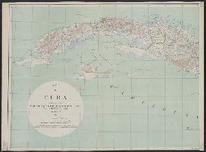
Creator
Essex, Frank B
Container / Volume
BRBL_00641
Description
occupation of Cuba, 1898-1902 and 1906-1909. Relief shown by contours and spot heights.
Published / Created
1911
Call Number
855 1911
Format
Digital Collection / Online / Cartographic / Maps & GIS
Found In
Access
Public
Creator
United States. Office of Strategic Services. Research and Analysis Branch
Container / Volume
BRBL_00298
Description
"25 October 1944." "From the Christian Occupation of China, published by China Continuation
Published / Created
[1944]
Call Number
56eb 1944
Format
Digital Collection / Online / Cartographic / Maps & GIS
Found In
Access
Public

Creator
China. Xing zheng yuan. Xin wen ju
Container / Volume
BRBL_00298
Description
by hachure Shows Chinese territories under Japanese occupation.
Published / Created
[1944]
Call Number
56fd 1944
Format
Digital Collection / Online / Cartographic / Maps & GIS
Found In
Access
Public

Creator
Kokkins, John M
Container / Volume
BRBL_00265
Description
.D. and during the Latin occupation -- Greece after World War I -- Greece after World War II. Some maps include
Published / Created
c1943.
Call Number
48j 1943
Format
Digital Collection / Online / Cartographic / Maps & GIS
Found In
Access
Public
