- No16
Container / Volume
BRBL_00023
Published / Created
[1860?]
Call Number
267 1860
Format
Digital Collection / Online / Cartographic / Maps & GIS
Access
Public

Creator
Wyld, James, 1812-1887
Container / Volume
BRBL_00023
Description
Insets: Plan of the entrance to Port Manoukao -- Plan of Victoria Bay of Islands New Zealand
Published / Created
[186-?]
Call Number
267 1865
Format
Digital Collection / Online / Cartographic / Maps & GIS
Found In
Access
Public
Subject (Name)
New Zealand Company

Creator
Crawford, R. J
Container / Volume
BRBL_00023A
Published / Created
1908
Call Number
267cbf B64 1908
Format
Digital Collection / Online / Cartographic / Maps & GIS
Found In
Access
Public
Subject (Name)
New Zealand Geological Survey

Creator
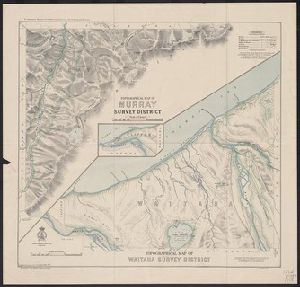
Crawford, R. J
Container / Volume
BRBL_00023A
Published / Created
1908
Call Number
267cbf W1347 1908
Format
Digital Collection / Online / Cartographic / Maps & GIS
Found In
Access
Public
Subject (Name)
New Zealand Geological Survey
Creator
Coronelli, Vincenzo, 1650-1718
Container / Volume
BRBL_00735
Published / Created
1693-1707]
Call Number
23 1693 9
Format
Digital Collection / Online / Cartographic / Maps & GIS
Found In
Access
Public

Container / Volume
BRBL_00023A
Published / Created
1915?]
Call Number
267ag 1915
Format
Digital Collection / Online / Cartographic / Maps & GIS
Found In
Access
Public
Subject (Topic)
Transportation--New Zealand--Maps
Creator
Automobile Association (Auckland)
Container / Volume
BRBL_00023A
Published / Created
[1945?]
Call Number
267gmb R746 1949
Format
Digital Collection / Online / Cartographic / Maps & GIS
Access
Public
Subject (Topic)
Geothermal resources--New Zealand--Rotorua District--Maps and Roads--New Zealand--Rotorua District--Maps
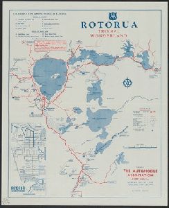
Creator
Automobile Association (Auckland)
Container / Volume
BRBL_00023A
Published / Created
[1944?]
Call Number
267gmb B34 1947
Format
Digital Collection / Online / Cartographic / Maps & GIS
Found In
Access
Public
Subject (Topic)
Roads--New Zealand--Islands, Bay of--Maps

Creator
New Zealand. Dept. of Lands and Survey
Container / Volume
BRBL_00023
Published / Created
1904
Call Number
267 1904
Format
Digital Collection / Online / Cartographic / Maps & GIS
Found In
Access
Public
Alternative Title
Middle Island, New Zealand

Creator
New Zealand. Dept. of Lands and Survey
Container / Volume
BRBL_00023
Published / Created
1904
Call Number
267 1904A
Format
Digital Collection / Online / Cartographic / Maps & GIS
Found In
Access
Public
Alternative Title
North Island, New Zealand
Creator
New Zealand. Dept. of Lands and Survey
Container / Volume
BRBL_00023A
Published / Created
1944
Call Number
267cbf 1952 5
Format
Digital Collection / Online / Cartographic / Maps & GIS
Access
Public
Creator
New Zealand. Dept. of Lands and Survey, Panton, W, and Royel, W
Container / Volume
BRBL_00023A
Description
"New Zealand 1:25000." Issued as sheet N164/6 in the series NZMS 2. Relief shown by contours
Published / Created
1945
Call Number
267cbf 1952 6
Format
Digital Collection / Online / Cartographic / Maps & GIS
Found In
Access
Public
Creator
Kitchin, Thomas, d. 1784
Container / Volume
BRBL_00681
Description
and New Zealand. Also shows time differences and some relief in hill shading.
Published / Created
1760?]
Call Number
11 1755A
Format
Digital Collection / Online / Cartographic / Maps & GIS
Found In
Access
Public

Creator
Zatta, Antonio, fl. 1757-1797
Container / Volume
BRBL_00724
Description
to New Zealand.
Published / Created
1776
Call Number
70 1776B
Format
Digital Collection / Online / Cartographic / Maps & GIS
Found In
Access
Public

Creator
Imray, James F. (James Frederick), 1829?-1891, cartographer and James Imray and Son, issuing body
Container / Volume
BRBL_00021
Description
, the Solomon Islands, New Hebrides, New Caledonia, and the northwest of New Zealand. Mellish Reef. Relief shown
Call Number
23cea 1886
Format
Digital Collection / Online / Cartographic / Maps & GIS
Found In
Access
Public
Creator
Zatta, Antonio, fl. 1757-1797
Container / Volume
BRBL_00356
Description
the Pacific Ocean to New Zealand.
Published / Created
1776
Call Number
70 1776A
Format
Digital Collection / Online / Cartographic / Maps & GIS
Found In
Access
Public
