Creator
Gibbes, Charles Drayton
Container / Volume
BRBL_00601
Published / Created
1852
Call Number
844 1852A
Format
Digital Collection / Online / Cartographic / Maps & GIS
Found In
Access
Public

Container / Volume
BRBL_00019
Published / Created
1780?]
Call Number
23 1780B
Format
Digital Collection / Online / Cartographic / Maps & GIS
Found In
Access
Public

Creator
Edward Weber & Co
Call Number
Zc10 845fr
Format
Digital Collection / Online / Cartographic
Found In
Access
Public

Call Number
Zc10 845fr
Format
Digital Collection / Online / Text
Found In
Access
Public

Creator
Royal Geographical Society (Great Britain)
Container / Volume
BRBL_00013
Description
Map showing the area explored by Ernest Shackleton's British Antarctic Expedition, 1907
Published / Created
1909
Call Number
19 1909A
Format
Digital Collection / Online / Cartographic / Maps & GIS
Found In
Access
Public
Alternative Title
General map showing the explorations and surveys of the Expedition, 1907-1909 and The Geographical journal.

Creator
Royal Geographical Society (Great Britain)
Container / Volume
BRBL_00023A
Published / Created
1911
Call Number
26912 1911
Format
Digital Collection / Online / Cartographic / Maps & GIS
Found In
Access
Public
Alternative Title
Central Papua, route and explorations of the expedition of D. Mackay and W.S. Little, 1908-9 and Route and explorations of the expedition of D. Mackay and W.S. Little, 1908-9

Creator
National Geographic Society (U.S.). Cartographic Division
Container / Volume
BRBL_00631
Published / Created
1914
Call Number
848 1914D
Format
Digital Collection / Online / Cartographic / Maps & GIS
Found In
Access
Public

Container / Volume
BRBL_00679
Published / Created
1910
Call Number
98fd 1910
Format
Digital Collection / Online / Cartographic / Maps & GIS
Found In
Access
Public

Creator
Stevens, Isaac Ingalls, 1818-1862
Container / Volume
BRBL_00620
Published / Created
[1855]
Call Number
845 1855
Format
Digital Collection / Online / Cartographic / Maps & GIS
Found In
Access
Public

Creator
Heywood, James
Container / Volume
BRBL_00367
Published / Created
1791]
Call Number
71 1791B
Format
Digital Collection / Online / Cartographic / Maps & GIS
Found In
Access
Public

Container / Volume
BRBL_00341
Published / Created
[between 1878 and 1897?]
Call Number
65 1877
Format
Digital Collection / Online / Cartographic / Maps & GIS
Found In
Access
Public

Container / Volume
BRBL_00382
Published / Created
1858
Call Number
736 1858
Format
Digital Collection / Online / Cartographic / Maps & GIS
Found In
Access
Public

Container / Volume
BRBL_00020
Published / Created
1840-1844.
Call Number
23 1844
Format
Digital Collection / Online / Cartographic / Maps & GIS
Found In
Access
Public

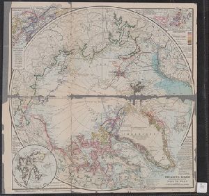
Creator
Grosvenor, Gilbert Hovey, 1875-1966
Container / Volume
BRBL_00013
Description
Color coded to show each exploration. Insets: Explorers of Franz Josef Land -- Spitzbergen.
Published / Created
c1910
Call Number
18 1910
Format
Digital Collection / Online / Cartographic / Maps & GIS
Found In
Access
Public
Container / Volume
BRBL_00300
Published / Created
1909
Call Number
567 1909
Format
Digital Collection / Online / Cartographic / Maps & GIS
Found In
Access
Public

Creator
Nell, Louis
Container / Volume
BRBL_00619
Published / Created
1868
Call Number
844gme 1868
Format
Digital Collection / Online / Cartographic / Maps & GIS
Found In
Access
Public

Creator
Ives, J. C
Container / Volume
BRBL_00537
Description
." Also shows routes of exploration. At head of title: Explorations and Surveys, War Department, map no. 1
Published / Created
1858
Call Number
80 C71 1858
Format
Digital Collection / Online / Cartographic / Maps & GIS
Found In
Access
Public
Publisher
Office of Explorations and Surveys,
Subject (Name)
Egloffstein, F., 1824-1885, Humphreys, A. A. (Andrew Atkinson), 1810-1883, Sartain, Samuel, 1830-1906, and United States. Office of Explorations and Surveys

Creator
Ives, J. C
Container / Volume
BRBL_00537
Description
shows routes of exploration. At head of title: Explorations and Surveys, War Department, map no. 2
Published / Created
1858
Call Number
80 C71 1858A
Format
Digital Collection / Online / Cartographic / Maps & GIS
Found In
Access
Public
Publisher
Office of Explorations and Surveys,
Subject (Name)
Egloffstein, F. W., 1824-1885, Humphreys, A. A. (Andrew Atkinson), 1810-1883, Sartain, Samuel, 1830-1906, and United States. Office of Explorations and Surveys

Creator
Garstin, William, Sir, 1849-1925
Container / Volume
BRBL_00329
Description
Speke's first journey ... 1856 -- Map showing the results of Burton, Speke, and Grant's explorations
Published / Created
1909
Call Number
60bh 1909
Format
Digital Collection / Online / Cartographic / Maps & GIS
Found In
Access
Public
Alternative Title
Maps of Eastern Equatorial Africa showing the progress of exploration

Creator
Garstin, William, Sir, 1849-1925
Container / Volume
BRBL_00335
Published / Created
1909
Call Number
63bh 1909
Format
Digital Collection / Online / Cartographic / Maps & GIS
Found In
Access
Public
Alternative Title
Maps of Eastern Equatorial Africa showing the progress of exploration

Container / Volume
BRBL_00687
Published / Created
179-?]
Call Number
71 1784
Format
Digital Collection / Online / Cartographic / Maps & GIS
Found In
Access
Public
Alternative Title
Chart of the northwest coast of America and the northeast coast of Asia, explored in the years 1778

Container / Volume
BRBL_00535
Published / Created
1870
Call Number
80 1870B
Format
Digital Collection / Online / Cartographic / Maps & GIS
Found In
Access
Public

Creator
Myers, Eveleen
Abstract
with which her husband, the explorer Henry Morton Sta
Container / Volume
Folder [9]
Published / Created
[1886-1938], Undated
Call Number
GEN MSS 280
Format
Digital Collection / Online / Text
Access
Public
Subject (Topic)
Actors --France and Explorers --Great Britain

Creator
Stanley, D. M
Abstract
with which her husband, the explorer Henry Morton Sta
Container / Volume
Folder [7]
Published / Created
1934-36
Call Number
GEN MSS 280
Format
Digital Collection / Online / Text
Access
Public
Subject (Topic)
Actors --France and Explorers --Great Britain

Creator
Stanley, Dorothy, Lady, d. 1926
Abstract
with which her husband, the explorer Henry Morton Stanley, was involved, and her travels. Also included are
Container / Volume
Folder [4]
Published / Created
1900-07
Call Number
GEN MSS 280
Format
Digital Collection / Online / Text
Access
Public
Subject (Topic)
Actors --France and Explorers --Great Britain