Container / Volume
BRBL_00375A
Description
In upper margin, left to right: Routes of explorers, 57, 58, Atlas of Canada.
Published / Created
191-?]
Call Number
73bh 1912
Format
Digital Collection / Online / Cartographic / Maps & GIS
Access
Public
Subject (Topic)
Explorers--Canada--Maps

Creator
Opper, Frederick Burr, 1857-1937, artist
Published / Created
[before 1937]
Call Number
Print01299
Format
Digital Collection / Online / Images
Found In
Access
Public
Subject (Topic)
Patent medicines, Explorers, and Advertisements

Creator
Sherwin, J. K. (John Keyse), 1751-1790, printmaker
Published / Created
[20 April 1779]
Call Number
Portraits C771 no. 1
Format
Digital Collection / Online / Images
Access
Public
Subject (Topic)
Explorers and British

Creator
Vertue, George, 1684-1756, artist
Published / Created
[between 1720 and 1756?]
Call Number
Folio 49 3581 v.1
Format
Digital Collection / Online / Images
Found In
Access
Public
Subject (Topic)
Explorers and British

Creator
New Mexico. State Tourist Bureau
Container / Volume
BRBL_00597
Published / Created
c1940.
Call Number
841am 1940
Format
Digital Collection / Online / Cartographic / Maps & GIS
Found In
Access
Public
Subject (Topic)
Explorers--New Mexico--Maps and Trails--New Mexico--Maps

Published / Created
[1938?]
Call Number
Zc43 938fa
Format
Digital Collection / Online / Mixed Material / Books
Found In
Access
Yale Community Only
Alternative Title
Gordon Campbell the explorer

Container / Volume
BRBL_00634
Published / Created
1898
Call Number
848 T15 1898
Format
Digital Collection / Online / Cartographic / Maps & GIS
Found In
Access
Public

Creator
Royal Geographical Society (Great Britain)
Container / Volume
BRBL_00329
Published / Created
1911
Call Number
60bh 1911
Format
Digital Collection / Online / Cartographic / Maps & GIS
Found In
Access
Public
Alternative Title
Exploration of Africa

Creator
Wyld, James, 1812-1887
Container / Volume
BRBL_00327
Published / Created
[1875?]
Call Number
60 1875
Format
Digital Collection / Online / Cartographic / Maps & GIS
Found In
Access
Public
Alternative Title
Africa, Map shewing the various explorations in Africa, and Wyld's map showing the various explorations in Africa

Container / Volume
BRBL_00392
Published / Created
[1886?]
Call Number
739GBC C19 1886E
Format
Digital Collection / Online / Cartographic / Maps & GIS
Found In
Access
Public

Creator
Watkins, Carleton E., 1829-1916.
Description
was the official photographer for King's Geological Exploration of the Fortieth Parallel. Letterpress captions
Published / Created
1870
Call Number
WA Photos Folio 21
Format
Digital Collection / Online / Images
Found In
Access
Public
Subject (Name)
King, Clarence, 1842-1901., United States Geological Exploration of the Fortieth Parallel (1867-1881), and United States Geological Exploration of the Fortieth Parallel--(1867-1881)--Pictorial works.

Creator
Canada. Dept. of the Interior
Container / Volume
BRBL_00013
Description
27 coastal sections with names of explorers; tracks of expedition.
Published / Created
1904
Call Number
18 1904
Format
Digital Collection / Online / Cartographic / Maps & GIS
Found In
Access
Public

Creator
Canada. Dept. of the Interior
Container / Volume
BRBL_00394
Description
27 coastal sections with names of explorers; tracks of expedition.
Published / Created
1904
Call Number
74 1904B
Format
Digital Collection / Online / Cartographic / Maps & GIS
Found In
Access
Public

Creator
Hutton, James D
Container / Volume
Box 1 | Folder 10
Published / Created
Undated
Call Number
WA MSS S-2403
Format
Digital Collection / Online / Images
Found In
Access
Public
Alternative Title
Mount Jefferson and Black Butte from camp Second Lieutenant Abbots exploration

Creator
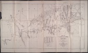
Raisz, Erwin, 1893-1968
Container / Volume
BRBL_00623
Published / Created
c1941.
Call Number
846cb 1941
Format
Digital Collection / Online / Cartographic / Maps & GIS
Found In
Access
Public

Creator
Steel, E. A., Lieut
Container / Volume
BRBL_00346
Published / Created
1908
Call Number
6551 1908
Format
Digital Collection / Online / Cartographic / Maps & GIS
Found In
Access
Public

Creator
Berthrong, I. P
Container / Volume
BRBL_00414A
Published / Created
1908
Call Number
75j 1908
Format
Digital Collection / Online / Cartographic / Maps & GIS
Found In
Access
Public
Subject (Topic)
Explorers--United States--Maps
Creator
Berthrong, I. P
Container / Volume
BRBL_00414A
Published / Created
1908
Call Number
75j 1908
Format
Digital Collection / Online / Cartographic / Maps & GIS
Found In
Access
Public
Subject (Topic)
Explorers--United States--Maps

Creator
Berthrong, I. P
Container / Volume
BRBL_00411
Published / Created
1908
Call Number
75gmb 1908
Format
Digital Collection / Online / Cartographic / Maps & GIS
Found In
Access
Public
Subject (Topic)
Explorers--United States--Maps

Creator
Mechlin, J. P
Call Number
Zc58 +876uo
Format
Digital Collection / Online / Cartographic
Found In
Access
Public
Container / Volume
BRBL_00314
Published / Created
1886
Call Number
582 1886
Format
Digital Collection / Online / Cartographic / Maps & GIS
Found In
Access
Public

Creator
Thompson, E. W., 1770-1847, printmaker
Published / Created
March 1796.
Call Number
Folio 724 812 B68
Format
Digital Collection / Online / Images
Access
Public
Subject (Topic)
Explorers, Globes, and Maps

Creator
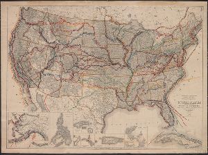
Warren, Gouverneur Kemble, 1830-1882
Container / Volume
BRBL_00534
Published / Created
1858?]
Call Number
80 1857E
Format
Digital Collection / Online / Cartographic / Maps & GIS
Found In
Access
Public
Subject (Topic)
Pacific railroads--Explorations and surveys--Maps and Railroads--West (U.S.)--Maps

Creator
Freyhold, Edward
Container / Volume
BRBL_00535
Published / Created
[1868]
Call Number
80 1868
Format
Digital Collection / Online / Cartographic / Maps & GIS
Found In
Access
Public
Subject (Topic)
Pacific railroads--Explorations and surveys--Maps and Railroads--West (U.S.)--Maps

Creator
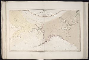
Faden, William, 1749-1836, Palmer, W. (William), 1739-1812, and Roberts, Henry, Lieut, creator
Published / Created
1784
Call Number
1982 Folio 10
Format
Digital Collection / Online / Cartographic
Found In
Access
Public
Alternative Title
Chart of the northwest coast of America and the northeast coast of Asia, explored in the years 1778