Creator
Gräf, A. (Adolf), active 1855-1878, cartographer
Container / Volume
BRBL_00347
Description
and select names and dates of European explorations from 1850 through 1860.
Call Number
66 1862
Format
Digital Collection / Online / Cartographic / Maps & GIS
Found In
Access
Public

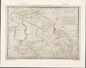
Creator
Lejean, Guillaume, 1824-1871, cartographer
Container / Volume
BRBL_00332
Description
and select names and dates of European explorations from 1849 through 1862.
Call Number
615 1862
Format
Digital Collection / Online / Cartographic / Maps & GIS
Found In
Access
Public

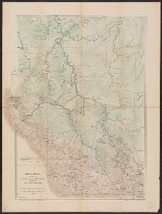
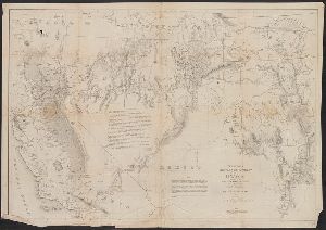
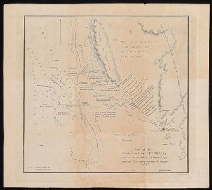
Creator
Sociedad Geográfica de Lima
Container / Volume
BRBL_00677
Description
Relief shown by shading. Shows exploration route of Sr. Coronel D. Pedro Portillo, some roads
Published / Created
1906
Call Number
97 1906A
Format
Digital Collection / Online / Cartographic / Maps & GIS
Found In
Access
Public
Creator
Bauman, William and Graphic Company
Container / Volume
BRBL_00013
Description
shown by hachures and spot heights. Shows destinations and some routes of arctic explorers 1553-1879.
Published / Created
[ca. 1879]
Call Number
18 1879
Format
Digital Collection / Online / Cartographic / Maps & GIS
Found In
Access
Public

Creator
Arrowsmith, John, 1790-1873, cartographer
Description
on explorers and discoveries. Map of Australia showing 19 counties in New South Wales, 26 counties in Western
Published / Created
Apl. 1st 1846.
Call Number
BrSides 2019 93
Format
Digital Collection / Online / Cartographic / Maps & GIS
Found In
Access
Public

Container / Volume
BRBL_00013
Description
, accompanying article titled "The Exploration of Prince Charles Foreland, 1906-1907" by William S. Bruce.
Published / Created
1908
Call Number
186 P93 1908
Format
Digital Collection / Online / Cartographic / Maps & GIS
Found In
Access
Public

Creator
Palmer, William Jackson, 1836-1909
Container / Volume
BRBL_00538
Description
, military and Indian reservations, wagon roads, trails, routes of exploration, and the railroad network
Published / Created
1868]
Call Number
80gme 1868
Format
Digital Collection / Online / Cartographic / Maps & GIS
Found In
Access
Public

Creator
Palmer, William Jackson, 1836-1909
Container / Volume
BRBL_00538
Description
, military and Indian reservations, wagon roads, trails, routes of exploration, and the railroad network
Published / Created
1868]
Call Number
80gme 1869A
Format
Digital Collection / Online / Cartographic / Maps & GIS
Found In
Access
Public

Creator
Geographical Surveys West of the 100th Meridian (U.S.)
Container / Volume
BRBL_00537
Description
, & 1876." Relief shown by hachures. Shows routes of explorations and surveys of the Army officers
Published / Created
1877
Call Number
80b 1877
Format
Digital Collection / Online / Cartographic / Maps & GIS
Found In
Access
Public

Creator
Littlehales, G. W. (George Washington), 1860-1943 and Sigsbee, Charles D. (Charles Dwight), 1845-1923
Container / Volume
BRBL_00013
Description
detailing exploration of coasts and tracks of expeditions.
Call Number
18 1896
Format
Digital Collection / Online / Cartographic / Maps & GIS
Found In
Access
Public

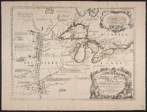
Creator
Chatelain, Henri Abraham
Container / Volume
BRBL_00354
Description
portraits of explorers, illustrations of indigenous peoples, wildlife, flora, historical notes
Published / Created
[1719]
Call Number
70 1719
Format
Digital Collection / Online / Cartographic / Maps & GIS
Found In
Access
Public

Abstract
, two boys in foreground, hills in the distance. ""Explorer U.S.A."" on the paddlewheel casing.
Container / Volume
Box 4 | Folder 145
Published / Created
1857
Call Number
WA Photos 271
Format
Digital Collection / Online / Images
Access
Public

Creator
Harrison, Richard Edes
Container / Volume
BRBL_00329
Description
Eight inset maps (scale 1:110,000,000) show rainfall, exploration, drainage, population, races
Published / Created
1941
Call Number
60C 1941
Format
Digital Collection / Online / Cartographic / Maps & GIS
Access
Public

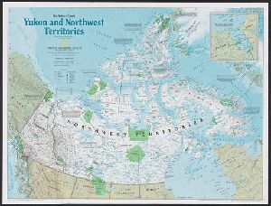
Creator
National Geographic Maps (Firm)
Container / Volume
BRBL_00395
Description
peoples -- 2. 1576 to 1870, exploration and the fur trade -- 3. 1870 to 1939, Canada's northward expansion
Published / Created
c1997.
Call Number
741 1997
Format
Digital Collection / Online / Cartographic / Maps & GIS
Found In
Access
Public
Creator
National Geographic Society (U.S.). Cartographic Section
Container / Volume
BRBL_00506
Description
Copyright: The National Geographic Society. Includes index of routes of exploration, text and ill
Published / Created
1940
Call Number
7821 1940
Format
Digital Collection / Online / Cartographic / Maps & GIS
Found In
Access
Public
Description
"The tale of exploring the caves at the foot of Mount Fuji", "A kana-zōshi." (K. Asakawa. "Gifts
Published / Created
Kanei 4 [1627]
Call Number
YAJ 6b6
Format
Digital Collection / Online / Mixed Material
Access
Public

Creator
H. Alt & Schröder, engravers, Justus Perthes (Firm : Gotha, Germany), publisher, Petermann, A. (August Heinrich), 1822-1878, and Stieler, Adolf, 1775-1836. Stieler's Hand-Atlas
Container / Volume
BRBL_00022
Description
showing explorers' tracks and railways. Relief shown by hachures and spot heights. Plate no. 73 from
Published / Created
[1873?]
Call Number
26 1873
Format
Digital Collection / Online / Cartographic / Maps & GIS
Access
Public

Creator
Geographical Surveys West of the 100th Meridian (U.S.)
Container / Volume
BRBL_00598
Description
."--Margin. Relief shown by hachures and spot heights. Sheet no. 75 from Wheeler's Geographical exploration
Published / Created
1876
Call Number
842 1876A
Format
Digital Collection / Online / Cartographic / Maps & GIS
Found In
Access
Public

Creator
Coronelli, Vincenzo, 1650-1718
Container / Volume
BRBL_00424
Description
on history of regional exploration, pictorial depictions
Published / Created
1688
Call Number
755 1688
Format
Digital Collection / Online / Cartographic / Maps & GIS
Found In
Access
Public
Creator
H. Alt & Schröder, engravers, Justus Perthes (Firm : Gotha, Germany), publisher, Petermann, A. (August Heinrich), 1822-1878, and Stieler, Adolf, 1775-1836. Stieler's Hand-Atlas
Container / Volume
BRBL_00022
Description
In German. In lower left margin: Rev. 1883. Map of Australia showing explorers' tracks, railways
Published / Created
[1883?]
Call Number
26 1883
Format
Digital Collection / Online / Cartographic / Maps & GIS
Found In
Access
Public

Creator
Ludlow, William, 1843-1901
Container / Volume
BRBL_00566
Description
heights. Shows exploration routes and dates.
Published / Created
[1874?]
Call Number
821 1874
Format
Digital Collection / Online / Cartographic / Maps & GIS
Found In
Access
Public

Creator
Mechlin, J. R. P
Container / Volume
BRBL_00417
Description
"Note. This map is mainly reduced from the official map, compiled in the Office of Explorations
Published / Created
1861
Call Number
754CBJ 1861
Format
Digital Collection / Online / Cartographic / Maps & GIS
Found In
Access
Public

Creator
National Geographic Society (U.S.). Cartographic Section
Container / Volume
BRBL_00536
Description
heights. Shows routes of exploration and includes notes on historical sites and points of interest.
Published / Created
1941
Call Number
80 1941
Format
Digital Collection / Online / Cartographic / Maps & GIS
Found In
Access
Public

Creator
Bartholomew, John, 1831-1893
Container / Volume
BRBL_00314
Description
"Compiled at the Revenue Survey Office, Selangor, from actural surveys and various explorations
Published / Created
[1904]
Call Number
5842 1904
Format
Digital Collection / Online / Cartographic / Maps & GIS
Found In
Access
Public

Creator
Dixon, Joseph
Container / Volume
BRBL_00534
Description
"From explorations made by h Date above scale statement: 1859. Date below legend: November 9th 1860
Published / Created
1860
Call Number
80 1859
Format
Digital Collection / Online / Cartographic / Maps & GIS
Found In
Access
Public

Abstract
Juan Riobo, and Father Matias Noriega as chaplains for the impending voyage of exploration along
Published / Created
1778 Dec 16
Call Number
WA MSS S-1506
Format
Digital Collection / Online / Text
Access
Public
Container / Volume
BRBL_00629
Description
of organization, and dates of some explorers.
Published / Created
1989
Call Number
847j 1989
Format
Digital Collection / Online / Cartographic / Maps & GIS
Found In
Access
Public

Creator
L'Isle, Guillaume de, 1675-1726
Container / Volume
BRBL_00426
Description
pictorially. Shows some explorers' routes.
Published / Created
[1730?]
Call Number
755 1730
Format
Digital Collection / Online / Cartographic / Maps & GIS
Found In
Access
Public

Creator
Zuerner, Adam Friedrich, 1680-1742
Container / Volume
BRBL_00680
Description
world map showing routes of explorers including Magellan, Dampier, Tasman and Chaumont. Includes twenty
Published / Created
[1709?]
Call Number
11 1709
Format
Digital Collection / Online / Cartographic / Maps & GIS
Found In
Access
Public

Description
Title from item. Verses below title: "O thou whose active search has dar'd explore far distant
Published / Created
Decr 9, 1775.
Call Number
775.12.09.01
Format
Digital Collection / Online
Access
Public

Creator
Miera y Pacheco, Bernardo de
Abstract
, in 1778. It reveals Spain's northernmost efforts to explore the interior of western North America
Published / Created
Año de 1778.
Call Number
WA MSS S-2856
Format
Digital Collection / Online / Cartographic
Found In
Access
Public
Creator
United States. Army. Corps of Topographical Engineers
Container / Volume
BRBL_00593
Description
of authorities. Relief shown by shading. Shows towns, wagon roads, explorers' routes, railroads, forts, etc
Published / Created
1862?]
Call Number
836ha 1860
Format
Digital Collection / Online / Cartographic / Maps & GIS
Found In
Access
Public
Abstract
When Carl Jung embarked on an extended self-exploration, the result was "The Red Book," a large
Call Number
2010 Folio 172
Format
Digital Collection / Online / Text
Access
Public

Abstract
When Carl Jung embarked on an extended self-exploration, the result was "The Red Book," a large
Call Number
2010 Folio 172
Format
Digital Collection / Online / Text
Access
Public

Abstract
When Carl Jung embarked on an extended self-exploration, the result was "The Red Book," a large
Call Number
2010 Folio 172
Format
Digital Collection / Online / Text
Access
Public

Creator
Imperatorskaia akademia nauk (Russia), Kitchin, Thomas, d. 1784, creator, and Sayer, Robert, 1725-1794
Description
, sailing and explorers tracks, etc.
Published / Created
1788 May 1
Call Number
1982 Folio 10
Format
Digital Collection / Online / Cartographic
Found In
Access
Public

Creator
Pope, Ralph W
Abstract
of an exploring party in the Fraser River region led by Franklin Leonard Pope, and his work in constructing
Published / Created
1865 May 17-1866 Apr 15.
Call Number
WA MSS S-1897
Format
Digital Collection / Online / Text
Found In
Access
Public

Creator
Marshall, Eric, 1879-1963
Container / Volume
BRBL_00013
Description
Map showing the area explored by Ernest Shackleton's Southern Journey Party over the period 1908
Published / Created
1909
Call Number
19 1909B
Format
Digital Collection / Online / Cartographic / Maps & GIS
Found In
Access
Public

Creator
Dávalos, José Manuel
Description
de Velasco October 1912" and "The South American Exploration Fund Yale University."
Published / Created
1815?]
Call Number
Peruvian Pamphlets 22
Format
Digital Collection / Online / Text
Found In
Beinecke Rare Book and Manuscript Library > Arenga que en el besamanos del 30 de Mayo de 1815 tenido en celebridad de los felices años de S. M. pronunció en nombre del Colegio de San Fernando el D. D. José Manuel Dávalos, maestro de dicho Colegio y catedrático de Materia Médica de la Real Universidad de San Márcos
Access
Public

Creator
Riobó, Juan
Abstract
's discoveries of 1775. Arteaga left San Blas in 1779, explored Bucareli Sound, the Northwest Coast to Mt. St
Container / Volume
Folder 1
Published / Created
1779
Call Number
WA MSS 12
Format
Digital Collection / Online / Text / Archives or Manuscripts
Found In
Beinecke Rare Book and Manuscript Library > Relacion del viaje echo ala alaska : pr. las fragatas de su Magd. la princesa y la favorita--mandada aquelta pr. el comandante de la expedicion y theniente de navio de la Real armada Dn. Ignacio Artheaga; siendo su segundo dela misma clase el Sr. Dn. Fernando Quiros y Miranda, y capitan de la favorita el oficial del mismo grado el [word crossed out] Dn. Jun. Francisco de la Bodega y Quadra...
Access
Public

Creator
Bowles, Carington, 1724-1793, cartographer.
Description
the voyages of some important explorers of the second half of the 18th century, including Cook's first voyage.
Published / Created
May 1780.
Call Number
11 1780B
Format
Digital Collection / Online / Cartographic / Maps & GIS
Found In
Access
Public

Creator
J. H. Gemrig
Container / Volume
Box 010
Description
a pair of angled forceps, an exploring director (manufactured by Hermann); a pair of slide-catch forceps
Published / Created
ca. early 19th century
Format
Digital Collection / Online / Images
Access
Public

Creator
Verjón de Cabiedes, Tomás
Description
of F. Perez de Velasco October 1912" and "The South American Exploration Fund Yale University."
Published / Created
1674?]
Call Number
Peruvian Pamphlets 21
Format
Digital Collection / Online / Text
Found In
Beinecke Rare Book and Manuscript Library > Genethliaco a los felicissimos años de la Reyna N.S. que celebró con real magnificencia el excele[n]tissimo señor conde de Castellar, marques de Malagon, virrey destos reynos, proseguida en el solemne aplauso genial al dia natal de Christo N. Señor / Doc. D. Tomas Verjon de Cabiedes, oydor desta Real Audiencia D.C.
Access
Public
Creator
Cruikshank, Isaac, 1764-1811, printmaker
Abstract
A group of men explore a cave Peak Cavern (in the heart of the Derbyshire Dales), some with candles
Published / Created
April 8, 1797.
Call Number
797.04.08.01
Format
Digital Collection / Online / Images
Access
Public

Description
explore. All bare and therefore all expresst. Temporary local subject terms: Ladies' costumes -- Hipless
Published / Created
Jany. 1788.
Call Number
788.01.01.01
Format
Digital Collection / Online / Images
Access
Public

Creator
Flores, Juan José, 1800-1864
Description
" and "The South American Exploration Fund Yale University.
Published / Created
1837
Call Number
Peruvian Pamphlets 23
Format
Digital Collection / Online / Text
Found In
Beinecke Rare Book and Manuscript Library > Dos composiciones poeticas / del Excmo. Sr. Juan Jose Flores, ex-presidente del estado del Ecuador, y jeneral en jefe de su ejercito, en su retiro de "La Elvira" ; seguidas de una oda al mismo jeneral, por uno de los muchos admiradores de sus talentos estadisticos y militares, y de sus virtudes morales.
Access
Public

Creator
Speed, John, 1552?-1629
Container / Volume
BRBL_00680
Description
astrological charts, allegorical figures representing the elements, and portraits in medallions of explorers
Published / Created
1651 [1676 printing]
Call Number
11 1651
Format
Digital Collection / Online / Cartographic / Maps & GIS
Found In
Access
Public

Creator
Knight, E. H. (Edward H.)
Container / Volume
BRBL_00538
Description
. It was completed in 1883 and approximates the route of exploration taken by Lewis and Clark in 1804-06.
Published / Created
1871]
Call Number
80gme 1871A
Format
Digital Collection / Online / Cartographic / Maps & GIS
Found In
Access
Public

Creator
Arrowsmith, John, 1790-1873, cartographer
Description
in Australia : with an account of the coasts and rivers explored and surveyed during the voyage of H
Published / Created
1846
Call Number
BrSides 2019 95
Format
Digital Collection / Online / Cartographic / Maps & GIS
Found In
Access
Public
Description
" and "The South American Exploration Fund Yale University.
Published / Created
176-?]
Call Number
Peruvian Pamphlets 23
Format
Digital Collection / Online / Text
Found In
Access
Public

Abstract
Papers pertaining to the 1789 Spanish exploration of the Northwest Coast of North America. Under
Published / Created
1791
Call Number
WA MSS S-662
Format
Digital Collection / Online / Text / Archives or Manuscripts
Found In
Access
Public
Abstract
Papers pertaining to the 1789 Spanish exploration of the Northwest Coast of North America. Under
Published / Created
1790
Call Number
WA MSS S-662
Format
Digital Collection / Online / Text / Archives or Manuscripts
Found In
Access
Public
Abstract
Papers pertaining to the 1789 Spanish exploration of the Northwest Coast of North America. Under
Published / Created
1789
Call Number
WA MSS S-662
Format
Digital Collection / Online / Text / Archives or Manuscripts
Found In
Access
Public

Abstract
Papers pertaining to the 1789 Spanish exploration of the Northwest Coast of North America. Under
Published / Created
1792, n.d.
Call Number
WA MSS S-662
Format
Digital Collection / Online / Text / Archives or Manuscripts
Access
Public

Abstract
Papers pertaining to the 1789 Spanish exploration of the Northwest Coast of North America. Under
Published / Created
1788
Call Number
WA MSS S-662
Format
Digital Collection / Online / Text / Archives or Manuscripts
Access
Public

Abstract
Papers pertaining to the 1789 Spanish exploration of the Northwest Coast of North America. Under
Published / Created
1785-1786
Call Number
WA MSS S-662
Format
Digital Collection / Online / Text / Archives or Manuscripts
Access
Public

Creator
Smith, B. M. (Byron M.)
Container / Volume
BRBL_00566
Description
roads, historic routes of exploration, areas of Indian habitation, railroads, cities, and existing
Published / Created
1861
Call Number
821 1861
Format
Digital Collection / Online / Cartographic / Maps & GIS
Found In
Access
Public

Container / Volume
File 17980
Description
....going out again next year to explore Mackenzie's River"; and "the Bishop of Ohio", who was soliciting
Published / Created
1818-37
Call Number
OSB MSS FILE
Format
Digital Collection / Online
Found In
Access
Public

Creator
Moziño, José Mariano, 1757-1820?
Abstract
. There are also references to the explorations of the Americans John Kendrick and the trader Robert Gray.
Published / Created
1793
Call Number
WA MSS S-1514
Format
Digital Collection / Online / Text
Found In
Access
Public

Creator
Emmons, George F. (George Foster), 1811-1884
Container / Volume
Box 1
Description
of the Exploring Expedition, which preceded the Wilkes trial (August 17), and a few trials following that of Wilkes
Published / Created
1842
Call Number
WA MSS 166-169, WA MSS S-4386
Format
Digital Collection / Online
Found In
Beinecke Rare Book and Manuscript Library > George F. Emmons papers > Series WA MSS.169: Scrapbook, 1842 - 1842 > Scrapbook of mounted clippings from the New York Express, reporting the proceedings of the Naval General Court Martial on board the U.S. Ship North Carolina, at New York, July 27 to September 15, 1842.
Access
Public

Description
: Map showing the route pursued by the exploring expedition to New Mexico and the southern Rocky
Published / Created
1846?]
Call Number
Zc20 846un
Format
Digital Collection / Online / Mixed Material / Books
Found In
Beinecke Rare Book and Manuscript Library > Message from the president of the United States : in compliance with a resolution of the Senate, communicating a report of an expedition led by Lieutenant Abert, on the upper Arkansas and through the country of the Camanche Indians, in the fall of the year 1845.
Access
Public

Creator
Meigs, Peveril, 1847-1921
Abstract
. Meigs served as captain's clerk on an expedition to explore the newly-acquired territory on the U
Container / Volume
Box 1 | Folder 2
Published / Created
n.d.
Call Number
WA MSS S-2718
Format
Digital Collection / Online / Text / Archives or Manuscripts
Access
Public

Description
plates. Caption title. Map entitled: Map showing the route pursued by the exploring expedition to New
Published / Created
1846?]
Call Number
Zc20 846un
Format
Digital Collection / Online / Images / Books
Found In
Beinecke Rare Book and Manuscript Library > Message from the president of the United States : in compliance with a resolution of the Senate, communicating a report of an expedition led by Lieutenant Abert, on the upper Arkansas and through the country of the Camanche Indians, in the fall of the year 1845.
Access
Public

Creator
Woodward, G. M. (George Moutard), approximately 1760-1809, printmaker
Abstract
understanding, he is up every morning exploring the works of Nature* he will make his way through the world
Published / Created
[20 January 1796]
Call Number
796.01.20.01
Format
Digital Collection / Online / Images
Access
Public

Creator
George Custer
Abstract
A letter dated Oct. 1, 1866 from Custer in Monroe, Michigan to C. F. Hatch, Superintendant of the S and , entitled Military Map of Nebraska and Dakota by Lieut. G. K. Warren, Topl. Engrs. From the Explorations
Container / Volume
Box 1 | Folder 2
Published / Created
1866 Oct 1
Call Number
WA MSS S-1643
Format
Digital Collection / Online / Text
Access
Public

Creator
Jephson, Robert, 1736-1803
Abstract
to explore the countryside. Traveling with Dean Marlay, Mrs Greville and Mrs Jephson, he complains about and Horace Walpole has filled in Johnson's name and added "By Richard Jephson, Esqre" underneath
Published / Created
1776
Call Number
LWL Mss Vol. 169
Format
Digital Collection / Online / Others
Access
Public

Abstract
of miracles. In Naples he explores the Pausilippo and Mount Vesuvius, described as "standing like a sugar loaf and Manuscript on paper containing the narrative of a member of Lord Northumberland's retinue, possibly
Published / Created
[1681-1682]
Call Number
Osborn b352
Format
Digital Collection / Online / Mixed Material
Found In
Access
Public

Container / Volume
BRBL_00686
Description
. Cross Collection nos. 67 and 136. Shows nautical exploration routes. Title from sheets 1 and 2.
Published / Created
[1783?]
Call Number
70 1775
Format
Digital Collection / Online / Cartographic / Maps & GIS
Found In
Access
Public

Creator
Chattock, Sarah
Abstract
and superstitions. She explores the town of Ashborne and Ashborne School, while a guest at Sandy Brook, the home
Published / Created
1797
Call Number
LWL Mss Vol. 45
Format
Digital Collection / Online / Others
Found In
Lewis Walpole Library > A tour through a part of the counties of Derby and Stafford : with various observations interspersed throughout the work by her brother The Reverend Mark Noble, F.A.S.s of London and Edinburgh, Rector of Barming in Kent, and domestic chaplain to George, Earl Leicester, written for the amusement and gratification of the parties and their friends, 1797
Access
Public

Creator
Speed, John, 1552?-1629
Description
Zembla [i.e. the archipelago Novaya Zemlya] by the Dutch explorer William Hollander in 1594-96. Watermark.
Call Number
Lanman 50 1676
Format
Digital Collection / Online / Cartographic / Maps & GIS
Found In
Access
Public

Creator
Gell, William, Sir, 1777-1836
Abstract
Manuscript, in a single hand, of a travel diary of the author's tour of Germany, Switzerland and of Dilettanti and a fellow of the Royal Society. In 1811 the Society of Dilettanti commissioned him to explore
Published / Created
1814 Aug 9 - 1815 May 31
Call Number
Osborn d293
Format
Digital Collection / Online / Text / Archives or Manuscripts
Access
Public
Creator
Ten Broeck, Peter G. Stuyvesant
Abstract
A manuscript map of the region that Ten Broeck traveled through and described, drawn by Ernest and exploration of the northeast Arizona region where the Hopi live, transcribed and annotated by Major Backus
Published / Created
1852 Apr 23 and 1852 Mar - Apr
Call Number
WA MSS S-2493 T252
Format
Digital Collection / Online / Text / Archives or Manuscripts
Found In
Access
Public

Creator
Boglár, Lajos. Erschaffung der Welt und ihrer Dinge, Heinze, Frieder, 1950-, Krause, Fritz, 1881-1963, Marquardt, Hans, Seattle, Chief, 1790-1866, Wegewitz, Olaf, and Werner, Klaus, 1938- Obsession der Moderne
Description
by notebooks kept by anthropologist Fritz Krause while exploring central Brazil in 1908
Published / Created
1985
Call Number
2007 Folio 24
Format
Digital Collection / Online / Mixed Material
Found In
Beinecke Rare Book and Manuscript Library > Unaulutu = Steinchen im Sand : ein Malerbuch / von Frieder Heinze und Olaf Wegewitz ; mit 68 graphischen Blättern, Annotationen der Künstler und 26 Reproduktionen nach Zeichnungen der Karaja-Indianer ; das Buch ist versehen mit "Spielelementen" wie Schwirrholz, Reiskörnen, Schilfrohr, Flechtwerk von Palmblättern, Bambus, handgefertigtem Papier aus Rindenbast und Brennesseln ; es enthält eine Abhandlung über indianische Mythen von Lajos Boglár und den Essay "Die Obsession der Moderne" von Klaus Werner, sowie "Ketschua-Lyrik" aus Peru und die legendäre Rede des Häuptlings Seattle "Wir sind ein Teil der Erde," gehalten vor dem Präsidenten der Vereinigten Staaten von Amerika im Jahre 1855 ; herausgegeben von Hans Marquardt ; mit Marginalien zum sechsten Druck der Dürer-Presse.
Access
Public

Creator
Hincks, John, 1788-1842
Abstract
Holograph journal in two versions (original and fair copy) of a tour from London to Naples, for three weeks, attending concerts, balls, and conversazioni, exploring the local antiquities, and climbing, Following their departure from Naples they spent a month in Rome, visiting museums, galleries, Original annotated on front pastedown with title and note: "note upon the above (made on the day, Fair copy contains tipped-in portrait engraving of Francis Joseph Charles, Duc de Reichstadt, and With: 5 autograph letters, signed, to John Hincks from Thomas Hincks; 2 autograph letters, signed
Published / Created
1823
Call Number
Osborn d408
Format
Digital Collection / Online / Others
Found In
Access
Public

Creator
Tocqueville, Alexis de, 1805-1859
Container / Volume
Box 30
Description
to explore the background of Beaumont's thinking in Chateaubriand, in the uprising of Toussaint L
Published / Created
1832-1840
Call Number
GEN MSS 982
Format
Digital Collection / Online
Found In
Access
Public
