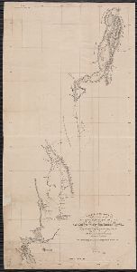
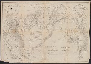
Creator
Zuerner, Adam Friedrich, 1680-1742
Container / Volume
BRBL_00680
Description
world map showing routes of explorers including Magellan, Dampier, Tasman and Chaumont. Includes twenty
Published / Created
[1709?]
Call Number
11 1709
Format
Digital Collection / Online / Cartographic / Maps & GIS
Found In
Access
Public

Creator
Wyse, Lucien N. B. (Lucien Napoléon Bonaparte), 1845-1909
Container / Volume
BRBL_00660
Published / Created
1886
Call Number
899 1885
Format
Digital Collection / Online / Cartographic / Maps & GIS
Found In
Access
Public

Creator
Wyld, James, 1812-1887
Container / Volume
BRBL_00327
Published / Created
[1875?]
Call Number
60 1875
Format
Digital Collection / Online / Cartographic / Maps & GIS
Found In
Access
Public
Alternative Title
Africa, Map shewing the various explorations in Africa, and Wyld's map showing the various explorations in Africa

Creator
Woodward, G. M. (George Moutard), approximately 1760-1809, printmaker
Abstract
understanding, he is up every morning exploring the works of Nature* he will make his way through the world
Published / Created
[20 January 1796]
Call Number
796.01.20.01
Format
Digital Collection / Online / Images
Access
Public

Creator
Williamson, R. S. (Robert Stockton), 1824-1882
Container / Volume
BRBL_00601
Published / Created
1849 or 1850]
Call Number
844 1849A
Format
Digital Collection / Online / Cartographic / Maps & GIS
Found In
Access
Public
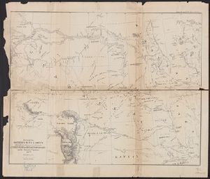
Creator
William P. Blake
Container / Volume
Report of explorations in California for railroad routes, to connect with the routes near the 35
Published / Created
1855
Call Number
WA Prints 39
Format
Digital Collection / Online / Cartographic
Found In
Access
Public

Creator
Wilkes, Charles, 1798-1877
Container / Volume
BRBL_00533
Description
Appears in the author's Narrative of the United States Exploring Expedition ... 1845. Includes
Published / Created
[1845]
Call Number
80 1841B
Format
Digital Collection / Online / Cartographic / Maps & GIS
Found In
Access
Public
Subject (Name)
Sherman & Smith, United States Exploring Expedition (1838-1842), and Young, J. H. (James Hamilton)

Creator
Wilkes, Charles, 1798-1877
Container / Volume
BRBL_00533
Description
in the author's Narrative of the United States Exploring Expedition ... 1845. Includes inset of "Columbia River
Published / Created
[1845]
Call Number
80 1841B
Format
Digital Collection / Online / Cartographic / Maps & GIS
Found In
Access
Public
Subject (Name)
Sherman & Smith, United States Exploring Expedition (1838-1842), and Young, J. H. (James Hamilton)
Creator
Wilkes, Charles, 1798-1877
Container / Volume
BRBL_00533
Published / Created
[1845?]
Call Number
80 1841A
Format
Digital Collection / Online / Cartographic / Maps & GIS
Found In
Access
Public
Subject (Name)
United States Exploring Expedition (1838-1842) and Wyld, James, 1812-1887

Creator
Wilkes, Charles, 1798-1877.
Description
of Congress, Aug. 26, 1842, the edition of the reports of the U.S. Exploring Expedition were limited to 100
Published / Created
1845
Call Number
Zc74 +844wib
Format
Digital Collection / Online / Text
Found In
Access
Public
Alternative Title
United States Exploring Expedition (1838-1842). United States Exploring Expedition ; v. 1-5. and United States exploring expedition, during the years 1838, 1839, 1840, 1841, 1842, under
Subject (Name)
United States Exploring Expedition--(1838-1842)

Creator
Whymper, Frederick
Abstract
The 23 views and 35 photographs were made on an 1864 exploring expedition of Vancouver Island.
Description
Frederick Whymper, artist, served on the 1864 Vancouver Island Exploring Expedition initiated
Published / Created
1864
Call Number
WA MSS 525
Format
Digital Collection / Online / Images
Access
Public
Subject (Name)
Vancouver Island Exploring Expedition and Whymper, Frederick
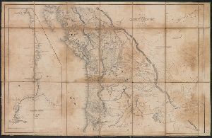
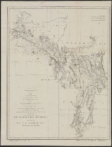
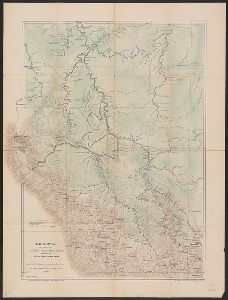
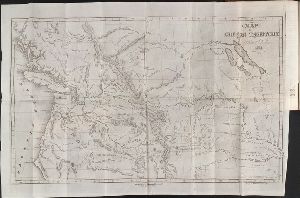
Creator
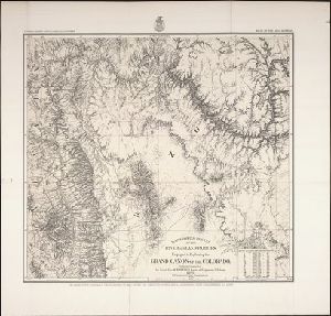
Wheeler, George M. (George Montague), 1842-1905
Container / Volume
BRBL_00592
Description
: Explorations in Nevada, Utah, & Arizona.
Published / Created
1872
Call Number
836 1872
Format
Digital Collection / Online / Cartographic / Maps & GIS
Found In
Access
Public
Alternative Title
Explorations in Nevada, Utah, & Arizona. and Explorations in Nevada, Utah, and Arizona.
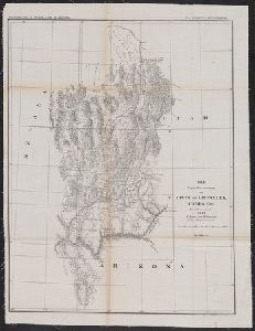
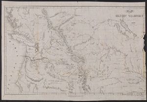
Creator
Wheeler, George M. (George Montague), 1842-1905
Container / Volume
BRBL_00598
Published / Created
1876
Call Number
842 1876B
Format
Digital Collection / Online / Cartographic / Maps & GIS
Found In
Access
Public
Alternative Title
Geological atlas projected to illustrate geographical explorations and surveys west of the 100 and Parts of eastern Arizona and western New Mexico

Creator
Welton, E. W
Container / Volume
BRBL_00595
Published / Created
[1866?]
Call Number
837gfc R25 1866
Format
Digital Collection / Online / Cartographic / Maps & GIS
Found In
Access
Public

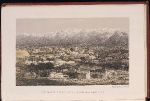
Creator
Watkins, Carleton E., 1829-1916.
Description
was the official photographer for King's Geological Exploration of the Fortieth Parallel. Letterpress captions
Published / Created
1870
Call Number
WA Photos Folio 21
Format
Digital Collection / Online / Images
Found In
Access
Public
Subject (Name)
King, Clarence, 1842-1901., United States Geological Exploration of the Fortieth Parallel (1867-1881), and United States Geological Exploration of the Fortieth Parallel--(1867-1881)--Pictorial works.

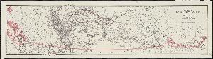
Creator
Warren, Gouverneur Kemble, 1830-1882
Container / Volume
BRBL_00525
Published / Created
1859
Call Number
796 1859A
Format
Digital Collection / Online / Cartographic / Maps & GIS
Found In
Access
Public
Subject (Name)
Bien, Julius, 1826-1909, Humphreys, A. A. (Andrew Atkinson), 1810-1883, and United States. Office of Explorations and Surveys

Creator
Warren, Gouverneur Kemble, 1830-1882
Published / Created
1858]
Call Number
80 1858
Format
Digital Collection / Online
Found In
Access
Public
Subject (Topic)
Railroads, Pacific railroads, and Explorations and surveys

Creator
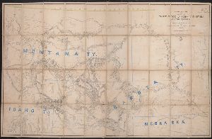
Warren, Gouverneur Kemble, 1830-1882
Container / Volume
BRBL_00534
Published / Created
1858?]
Call Number
80 1857E
Format
Digital Collection / Online / Cartographic / Maps & GIS
Found In
Access
Public
Subject (Topic)
Pacific railroads--Explorations and surveys--Maps and Railroads--West (U.S.)--Maps

Creator
Warren, Gouverneur Kemble, 1830-1882
Container / Volume
BRBL_00534
Description
At head of title: Explorations & surveys, War Dept., Hon. John B. Floyd, Secy. of War. Relief shown
Published / Created
1858?]
Call Number
80 1857A
Format
Digital Collection / Online / Cartographic / Maps & GIS
Found In
Access
Public
Subject (Name)
United States. Army. Corps of Topographical Engineers. Preliminary report of explorations and United States. Office of Explorations and Surveys

Creator
Warren, Gouverneur Kemble, 1830-1882
Container / Volume
BRBL_00534
Description
of explorations in Nebraska and Dakota in the years 1855-'56-'57," originally printed in the appendixes
Published / Created
1858]
Call Number
80 1857D
Format
Digital Collection / Online / Cartographic / Maps & GIS
Found In
Access
Public
Subject (Name)
United States. Army. Corps of Topographical Engineers. Preliminary report of explorations and United States. Office of Explorations and Surveys

Creator
Warren, Gouverneur Kemble, 1830-1882
Container / Volume
BRBL_00534
Description
explorations from 1820 to 1855 and locations of Indian tribes.
Published / Created
1856]
Call Number
80 1855B
Format
Digital Collection / Online / Cartographic / Maps & GIS
Found In
Access
Public
Creator
W. & A.K. Johnston Limited, cartographer
Container / Volume
BRBL_00327
Call Number
60 1889
Format
Digital Collection / Online / Cartographic / Maps & GIS
Found In
Access
Public
Alternative Title
Mr. H.M. Stanley's explorations in the Dark Continent :

Creator
Vincent Brooks Day & Son
Call Number
Zc10 869be
Format
Digital Collection / Online / Images
Access
Public
Subject (Topic)
Indians of North America --Southwest, New and Pacific railroads --Explorations and surveys

Creator
Vincent Brooks, Day & Son
Call Number
Zc10 869be
Format
Digital Collection / Online / Images
Access
Public
Subject (Topic)
Indians of North America --Southwest, New and Pacific railroads --Explorations and surveys

Creator
Vincent Brooks Day & Son
Call Number
Zc10 869be
Format
Digital Collection / Online / Images
Access
Public
Subject (Topic)
Indians of North America --Southwest, New and Pacific railroads --Explorations and surveys

Creator
Vincent Brooks Day & Son
Call Number
Zc10 869be
Format
Digital Collection / Online / Images
Access
Public
Subject (Topic)
Indians of North America --Southwest, New and Pacific railroads --Explorations and surveys
Creator
Vertue, George, 1684-1756, artist
Published / Created
[between 1720 and 1756?]
Call Number
Folio 49 3581 v.1
Format
Digital Collection / Online / Images
Found In
Access
Public
Subject (Topic)
Explorers and British

Creator
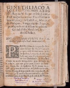
Verjón de Cabiedes, Tomás
Description
of F. Perez de Velasco October 1912" and "The South American Exploration Fund Yale University."
Published / Created
1674?]
Call Number
Peruvian Pamphlets 21
Format
Digital Collection / Online / Text
Found In
Beinecke Rare Book and Manuscript Library > Genethliaco a los felicissimos años de la Reyna N.S. que celebró con real magnificencia el excele[n]tissimo señor conde de Castellar, marques de Malagon, virrey destos reynos, proseguida en el solemne aplauso genial al dia natal de Christo N. Señor / Doc. D. Tomas Verjon de Cabiedes, oydor desta Real Audiencia D.C.
Access
Public
Creator
United States. Army. Dept. of the Pacific (1853-1858)
Call Number
Zc74 856un
Format
Digital Collection / Online / Text
Found In
Access
Public
Subject (Topic)
Pacific Coast Indians, Wars with, 1847-1865 and Pacific railroads --Explorations and surveys
Creator
United States. Army. Dept. of the Pacific (1853-1858)
Call Number
Zc74 856un
Format
Digital Collection / Online / Text
Found In
Access
Public
Subject (Topic)
Pacific Coast Indians, Wars with, 1847-1865 and Pacific railroads --Explorations and surveys

Creator
United States. Army. Corps of Topographical Engineers
Container / Volume
BRBL_00593
Description
of authorities. Relief shown by shading. Shows towns, wagon roads, explorers' routes, railroads, forts, etc
Published / Created
1862?]
Call Number
836ha 1860
Format
Digital Collection / Online / Cartographic / Maps & GIS
Found In
Access
Public
Creator
United States. Army. Corps of Engineers
Container / Volume
BRBL_00506
Description
, many still remaining en route." In upper margin: Explorations Preliminary report of explorations
Published / Created
1872?]
Call Number
7821 1872
Format
Digital Collection / Online / Cartographic / Maps & GIS
Found In
Access
Public
Alternative Title
Explorations in Nevada and Arizona. and Preliminary topographical map embracing in skeleton a portion only of the notes from surveys made
Subject (Name)
Lockwood, Daniel W, Lyle, D. A, Nell, Louis, United States. Army. Corps of Engineers. Preliminary report of explorations in Nevada and Arizona, and Wheeler, George M. (George Montague), 1842-1905
Creator
T. Sinclair's Lith., Philadelphia, Pennsylvania and William P. Blake
Container / Volume
Report of explorations in California for railroad routes, to connect with the routes near the 35
Published / Created
ca. 1855
Call Number
WA Prints 35
Format
Digital Collection / Online / Cartographic
Found In
Access
Public

Creator
T. Sinclair's Lith., Philadelphia, Pennsylvania
Container / Volume
Report of explorations in California for railroad routes, to connect with the routes near the 35
Published / Created
ca. 1855
Call Number
WA Prints 37
Format
Digital Collection / Online / Cartographic
Found In
Access
Public

Creator
T. Sinclair's Lith., Philadelphia, Pennsylvania and W. P. Blake
Container / Volume
Report of explorations in California for railroad routes, to connect with the routes near the 35
Published / Created
ca. 1855
Call Number
WA Prints 42
Format
Digital Collection / Online / Images
Found In
Access
Public

Creator
T. Sinclair's Lith., Philadelphia, Pennsylvania
Container / Volume
Report of explorations in California for railroad routes, to connect with the routes near the 35
Published / Created
ca. 1855
Call Number
WA Prints 20
Format
Digital Collection / Online / Images
Found In
Access
Public

Creator
T. Sinclair's Lith., Philadelphia, Pennsylvania and William P. Blake
Container / Volume
Report of explorations in California for railroad routes, to connect with the routes near the 35
Published / Created
ca. 1855
Call Number
WA Prints Folio 1
Format
Digital Collection / Online / Cartographic
Found In
Access
Public

Creator
T. Sinclair's Lith., Philadelphia, Pennsylvania and William P. Blake
Container / Volume
Report of explorations in California for railroad routes, to connect with the routes near the 35
Published / Created
ca. 1855
Call Number
WA Prints Folio 5
Format
Digital Collection / Online / Cartographic
Found In
Access
Public
Creator
Trautwine, John C. (John Cresson), 1810-1883
Container / Volume
BRBL_00658
Published / Created
1852]
Call Number
89 1866F
Format
Digital Collection / Online / Cartographic / Maps & GIS
Found In
Access
Public

Creator
Tocqueville, Alexis de, 1805-1859
Container / Volume
Box 30
Description
to explore the background of Beaumont's thinking in Chateaubriand, in the uprising of Toussaint L
Published / Created
1832-1840
Call Number
GEN MSS 982
Format
Digital Collection / Online
Found In
Access
Public

Creator
Thompson, E. W., 1770-1847, printmaker
Published / Created
March 1796.
Call Number
Folio 724 812 B68
Format
Digital Collection / Online / Images
Access
Public
Subject (Topic)
Explorers, Globes, and Maps

Creator
Thistlewood, Thomas, 1721-1786
Container / Volume
Box 10, folder 73
Description
Notes on scientific subjects, including electricity; natural history; travel and exploration
Published / Created
undated
Call Number
OSB MSS 176
Format
Digital Collection / Online
Found In
Access
Public
Creator
The Graphic Co. Photo.-Lith., New York, New York and Wyess, Thompson & Lang Del.
Container / Volume
Report upon United States Geographical surveys west of the one hundredth meridian in charge
Published / Created
"Issued Feb. 4th 1878."
Call Number
WA Prints +10
Format
Digital Collection / Online / Cartographic
Found In
Access
Public
Creator
Tennant, Gertrude, 1819-1918
Abstract
with which her husband, the explorer Henry Morton Stanley, was involved, and her travels. Also included are
Container / Volume
Folder [10]
Published / Created
1890-1908, Undated
Call Number
GEN MSS 280
Format
Digital Collection / Online / Text
Access
Public
Subject (Topic)
Actors --France and Explorers --Great Britain

Creator
Tennant, Dolly
Abstract
with which her husband, the explorer Henry Morton Sta
Container / Volume
Folder [8]
Published / Created
[1886-1938], Undated
Call Number
GEN MSS 280
Format
Digital Collection / Online / Text
Access
Public
Subject (Topic)
Actors --France and Explorers --Great Britain

Creator
Ten Broeck, Peter G. Stuyvesant
Abstract
A manuscript map of the region that Ten Broeck traveled through and described, drawn by Ernest and exploration of the northeast Arizona region where the Hopi live, transcribed and annotated by Major Backus
Published / Created
1852 Apr 23 and 1852 Mar - Apr
Call Number
WA MSS S-2493 T252
Format
Digital Collection / Online / Text / Archives or Manuscripts
Found In
Access
Public

Creator
Stevens, Isaac Ingalls, 1818-1862
Container / Volume
BRBL_00620
Published / Created
[1855]
Call Number
845 1855
Format
Digital Collection / Online / Cartographic / Maps & GIS
Found In
Access
Public

Creator
Steel, E. A., Lieut
Container / Volume
BRBL_00346
Published / Created
1908
Call Number
6551 1908
Format
Digital Collection / Online / Cartographic / Maps & GIS
Found In
Access
Public

Creator
Stanley, Dorothy, Lady, d. 1926
Abstract
with which her husband, the explorer Henry Morton Sta
Container / Volume
Folder [5]
Published / Created
[1886-1938], Undated
Call Number
GEN MSS 280
Format
Digital Collection / Online / Text
Access
Public
Subject (Topic)
Actors --France and Explorers --Great Britain

Creator
Stanley, Dorothy, Lady, d. 1926
Abstract
with which her husband, the explorer Henry Morton Stanley, was involved, and her travels. Also included are
Container / Volume
Folder [2]
Published / Created
1892-97
Call Number
GEN MSS 280
Format
Digital Collection / Online / Text
Access
Public
Subject (Topic)
Actors --France and Explorers --Great Britain

Creator
Stanley, Dorothy, Lady, d. 1926
Abstract
with which her husband, the explorer Henry Morton Stanley, was involved, and her travels. Also included are
Container / Volume
Folder [4]
Published / Created
1900-07
Call Number
GEN MSS 280
Format
Digital Collection / Online / Text
Access
Public
Subject (Topic)
Actors --France and Explorers --Great Britain
Creator
Stanley, Dorothy, Lady, d. 1926
Abstract
with which her husband, the explorer Henry Morton Stanley, was involved, and her travels. Also included are
Container / Volume
Folder [1]
Published / Created
1886-91
Call Number
GEN MSS 280
Format
Digital Collection / Online / Text
Access
Public
Subject (Topic)
Actors --France and Explorers --Great Britain

Creator
Stanley, Dorothy, Lady, d. 1926
Abstract
with which her husband, the explorer Henry Morton Stanley, was involved, and her travels. Also included are
Container / Volume
Folder [3]
Published / Created
1897-99
Call Number
GEN MSS 280
Format
Digital Collection / Online / Text
Access
Public
Subject (Topic)
Actors --France and Explorers --Great Britain

Creator
Stanley, Dorothy, Lady, d. 1926
Abstract
with which her husband, the explorer Henry Morton Sta
Container / Volume
Folder [6]
Published / Created
[1886-1938], Undated
Call Number
GEN MSS 280
Format
Digital Collection / Online / Text
Access
Public
Subject (Topic)
Actors --France and Explorers --Great Britain

Creator
Stanley, D. M
Abstract
with which her husband, the explorer Henry Morton Sta
Container / Volume
Folder [7]
Published / Created
1934-36
Call Number
GEN MSS 280
Format
Digital Collection / Online / Text
Access
Public
Subject (Topic)
Actors --France and Explorers --Great Britain

Creator
Speed, John, 1552?-1629
Container / Volume
BRBL_00680
Description
astrological charts, allegorical figures representing the elements, and portraits in medallions of explorers
Published / Created
1651 [1676 printing]
Call Number
11 1651
Format
Digital Collection / Online / Cartographic / Maps & GIS
Found In
Access
Public

Creator
Speed, John, 1552?-1629
Description
Zembla [i.e. the archipelago Novaya Zemlya] by the Dutch explorer William Hollander in 1594-96. Watermark.
Call Number
Lanman 50 1676
Format
Digital Collection / Online / Cartographic / Maps & GIS
Found In
Access
Public

Creator
Sociedad Geográfica de Lima
Container / Volume
BRBL_00677
Description
Relief shown by shading. Shows exploration route of Sr. Coronel D. Pedro Portillo, some roads
Published / Created
1906
Call Number
97 1906A
Format
Digital Collection / Online / Cartographic / Maps & GIS
Found In
Access
Public
Creator
Smith, B. M. (Byron M.)
Container / Volume
BRBL_00566
Description
roads, historic routes of exploration, areas of Indian habitation, railroads, cities, and existing
Published / Created
1861
Call Number
821 1861
Format
Digital Collection / Online / Cartographic / Maps & GIS
Found In
Access
Public

Creator
Simpson, J. H. (James Hervey), 1813-1883
Container / Volume
BRBL_00533
Published / Created
1850?]
Call Number
80 1849B
Format
Digital Collection / Online / Cartographic / Maps & GIS
Found In
Access
Public

Creator
Sherwin, J. K. (John Keyse), 1751-1790, printmaker
Published / Created
[20 April 1779]
Call Number
Portraits C771 no. 1
Format
Digital Collection / Online / Images
Access
Public
Subject (Topic)
Explorers and British

Creator
Scoresby, William, 1760-1829
Abstract
About the exploration of Greenland.
Published / Created
1817 Oct 2
Call Number
WA MSS S-423 Sco82
Format
Digital Collection / Online / Text / Archives or Manuscripts
Access
Public
Creator
Sarychev, Gavriil Andreevich, 1763-1831
Published / Created
1952.
Call Number
Eeac 785Rc
Format
Digital Collection / Online
Found In
Access
Public
Subject (Topic)
Discovery and exploration

Creator
Sarony, Major & Knapp Lith, [New York, New York] and William P. Blake
Container / Volume
Report of explorations in California for railroad routes, to connect with the routes near the 35
Published / Created
ca. 1855
Call Number
WA Prints +1
Format
Digital Collection / Online / Images
Found In
Access
Public
Creator
Royal Geographical Society (Great Britain)
Container / Volume
BRBL_00329
Published / Created
1911
Call Number
60bh 1911
Format
Digital Collection / Online / Cartographic / Maps & GIS
Found In
Access
Public
Alternative Title
Exploration of Africa

Creator
Royal Geographical Society (Great Britain)
Container / Volume
BRBL_00013
Description
Map showing the area explored by Ernest Shackleton's British Antarctic Expedition, 1907
Published / Created
1909
Call Number
19 1909A
Format
Digital Collection / Online / Cartographic / Maps & GIS
Found In
Access
Public
Alternative Title
General map showing the explorations and surveys of the Expedition, 1907-1909 and The Geographical journal.

Creator
Royal Geographical Society (Great Britain)
Container / Volume
BRBL_00023A
Published / Created
1911
Call Number
26912 1911
Format
Digital Collection / Online / Cartographic / Maps & GIS
Found In
Access
Public
Alternative Title
Central Papua, route and explorations of the expedition of D. Mackay and W.S. Little, 1908-9 and Route and explorations of the expedition of D. Mackay and W.S. Little, 1908-9

Creator
Romans, Bernard, ca. 1720-ca. 1784
Call Number
Egk24 775R
Format
Digital Collection / Online / Images
Found In
Access
Public

Creator
Robinson, W. W. (William Wilcox), 1891-1972
Container / Volume
BRBL_00612
Published / Created
c1956.
Call Number
844ag 1956
Format
Digital Collection / Online / Cartographic / Maps & GIS
Found In
Access
Public

Creator
Riobó, Juan
Abstract
's discoveries of 1775. Arteaga left San Blas in 1779, explored Bucareli Sound, the Northwest Coast to Mt. St
Container / Volume
Folder 1
Published / Created
1779
Call Number
WA MSS 12
Format
Digital Collection / Online / Text / Archives or Manuscripts
Found In
Beinecke Rare Book and Manuscript Library > Relacion del viaje echo ala alaska : pr. las fragatas de su Magd. la princesa y la favorita--mandada aquelta pr. el comandante de la expedicion y theniente de navio de la Real armada Dn. Ignacio Artheaga; siendo su segundo dela misma clase el Sr. Dn. Fernando Quiros y Miranda, y capitan de la favorita el oficial del mismo grado el [word crossed out] Dn. Jun. Francisco de la Bodega y Quadra...
Access
Public

Creator
Raynolds, W. F. (William Franklin), 1820-1894
Container / Volume
BRBL_00535
Published / Created
[1860]
Call Number
80 1860A
Format
Digital Collection / Online / Cartographic / Maps & GIS
Found In
Access
Public
Creator
Raynolds, W. F. (William Franklin), 1820-1894
Container / Volume
BRBL_00535
Published / Created
[1860]
Call Number
80 1860A
Format
Digital Collection / Online / Cartographic / Maps & GIS
Found In
Access
Public

Creator
Raynolds, W.F
Container / Volume
Box 25 | Folder 394
Published / Created
1869 Nov 19
Call Number
WA MSS S-1314
Format
Digital Collection / Online / Cartographic
Found In
Access
Public
Creator
Raisz, Erwin, 1893-1968
Container / Volume
BRBL_00623
Published / Created
c1941.
Call Number
846cb 1941
Format
Digital Collection / Online / Cartographic / Maps & GIS
Found In
Access
Public

Creator
Pope, Ralph W
Abstract
of an exploring party in the Fraser River region led by Franklin Leonard Pope, and his work in constructing
Published / Created
1865 May 17-1866 Apr 15.
Call Number
WA MSS S-1897
Format
Digital Collection / Online / Text
Found In
Access
Public

Creator
Petermann, A. (August Heinrich), 1822-1878
Container / Volume
BRBL_00339
Description
, and other official documents, combined with the results of their own explorations by F. Jeppe and A
Published / Created
1868
Call Number
643 1868
Format
Digital Collection / Online / Cartographic / Maps & GIS
Found In
Access
Public

Creator
Passe, Crispijn van de, ca. 1565-1637
Published / Created
1598]
Call Number
Taylor 216
Format
Digital Collection / Online / Mixed Material / Books
Found In
Beinecke Rare Book and Manuscript Library > Effigies regvm ac principum, eorum scilicet, quor[que] vis ac potentia in re nautica seu marina prae caeteris spectabilis est. : Quibus propter materie affinitatem adiecte sunt et imagines praestantissimorum ac maximè illustrium heroum, quorum virtus ac solertia in expeditionibus nauticis praecipuè claruit / Summa diligentia et artificio depictae, et tabellis aeneis incisae à Crispiano Passaeo Zelando ; Adiectis in singulas hexastichis Matthiae Quadi chalcographi.
Access
Public
Subject (Topic)
Explorers--Portraits and Kings and rulers--Portraits
Creator
Parker, Samuel, 1779-1866 and Peabody, M. M. (Moody Morse), 1789-1866
Description
Between p. 127 & p. 128. Map also appears in Parker, Samuel, 1779-1866. Journal of an exploring
Published / Created
1838
Call Number
Zc74 Or4
Format
Digital Collection / Online / Cartographic
Access
Public
Creator
Parker, Samuel, 1779-1866
Container / Volume
BRBL_00532
Description
From the author's Journal of an exploring tour beyond the Rocky mountains. 1838. In lower right
Published / Created
1838
Call Number
80 1838A
Format
Digital Collection / Online / Cartographic / Maps & GIS
Access
Public
Subject (Name)
Parker, Samuel, 1779-1866. Journal of an exploring tour beyond the Rocky mountains and Peabody, M. M
Creator
Pantoja y Arriaga, Juan
Abstract
Extract from a diary of the second mate on a Spanish voyage to explore the northern coast
Published / Created
1788
Call Number
WA MSS S-216
Format
Digital Collection / Online / Text
Access
Public

Creator
Palmer, William Jackson, 1836-1909
Container / Volume
BRBL_00538
Description
, military and Indian reservations, wagon roads, trails, routes of exploration, and the railroad network
Published / Created
1868]
Call Number
80gme 1868
Format
Digital Collection / Online / Cartographic / Maps & GIS
Found In
Access
Public

Creator
Palmer, William Jackson, 1836-1909
Container / Volume
BRBL_00538
Description
, military and Indian reservations, wagon roads, trails, routes of exploration, and the railroad network
Published / Created
1868]
Call Number
80gme 1869A
Format
Digital Collection / Online / Cartographic / Maps & GIS
Found In
Access
Public

Creator
Palliser, John, 1807-1887
Container / Volume
BRBL_00388
Published / Created
[1968?]
Call Number
739 1857
Format
Digital Collection / Online / Cartographic / Maps & GIS
Found In
Access
Public
Subject (Name)
British North American Exploring Expedition (1857-1860), Edward Stanford Ltd, Hector, James, Sir, 1834-1907, and Robert MacLehose & Co
Creator
Opper, Frederick Burr, 1857-1937, artist
Published / Created
[before 1937]
Call Number
Print01299
Format
Digital Collection / Online / Images
Found In
Access
Public
Subject (Topic)
Patent medicines, Explorers, and Advertisements

Creator
New Mexico. State Tourist Bureau
Container / Volume
BRBL_00597
Published / Created
c1940.
Call Number
841am 1940
Format
Digital Collection / Online / Cartographic / Maps & GIS
Found In
Access
Public
Subject (Topic)
Explorers--New Mexico--Maps and Trails--New Mexico--Maps

Creator
Nell, Louis
Container / Volume
BRBL_00619
Published / Created
1868
Call Number
844gme 1868
Format
Digital Collection / Online / Cartographic / Maps & GIS
Found In
Access
Public

Creator
National Geographic Society (U.S.). Cartographic Section
Container / Volume
BRBL_00536
Description
heights. Shows routes of exploration and includes notes on historical sites and points of interest.
Published / Created
1941
Call Number
80 1941
Format
Digital Collection / Online / Cartographic / Maps & GIS
Found In
Access
Public

Creator
National Geographic Society (U.S.). Cartographic Section
Container / Volume
BRBL_00506
Description
Copyright: The National Geographic Society. Includes index of routes of exploration, text and ill
Published / Created
1940
Call Number
7821 1940
Format
Digital Collection / Online / Cartographic / Maps & GIS
Found In
Access
Public
Creator
National Geographic Society (U.S.). Cartographic Division
Container / Volume
BRBL_00631
Published / Created
1914
Call Number
848 1914D
Format
Digital Collection / Online / Cartographic / Maps & GIS
Found In
Access
Public

Creator
National Geographic Society (U.S.)
Container / Volume
BRBL_00013
Description
Depths indicated by soundings. Routes of explorers traced.
Published / Created
1907
Call Number
18 1907
Format
Digital Collection / Online / Cartographic / Maps & GIS
Found In
Access
Public

Creator
National Geographic Maps (Firm)
Container / Volume
BRBL_00395
Description
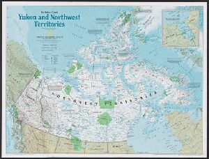
peoples -- 2. 1576 to 1870, exploration and the fur trade -- 3. 1870 to 1939, Canada's northward expansion
Published / Created
c1997.
Call Number
741 1997
Format
Digital Collection / Online / Cartographic / Maps & GIS
Found In
Access
Public
Creator
Myers, Eveleen
Abstract
with which her husband, the explorer Henry Morton Sta
Container / Volume
Folder [9]
Published / Created
[1886-1938], Undated
Call Number
GEN MSS 280
Format
Digital Collection / Online / Text
Access
Public
Subject (Topic)
Actors --France and Explorers --Great Britain

Creator
Moziño, José Mariano, 1757-1820?
Abstract
. There are also references to the explorations of the Americans John Kendrick and the trader Robert Gray.
Published / Created
1793
Call Number
WA MSS S-1514
Format
Digital Collection / Online / Text
Found In
Access
Public

Creator
Mollhausen, H. B
Published / Created
1861
Call Number
Zc50 +861un
Format
Digital Collection / Online / Images
Found In
Access
Public

Creator
Miera y Pacheco, Bernardo de
Abstract
, in 1778. It reveals Spain's northernmost efforts to explore the interior of western North America
Published / Created
Año de 1778.
Call Number
WA MSS S-2856
Format
Digital Collection / Online / Cartographic
Found In
Access
Public
Creator
Meigs, Peveril, 1847-1921
Abstract
. Meigs served as captain's clerk on an expedition to explore the newly-acquired territory on the U
Container / Volume
Box 1 | Folder 2
Published / Created
n.d.
Call Number
WA MSS S-2718
Format
Digital Collection / Online / Text / Archives or Manuscripts
Access
Public
