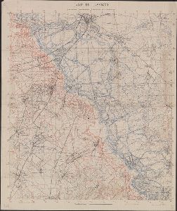
Published / Created
1968
Call Number
BrSides Folio 2008 171
Format
Digital Collection / Online / Images
Access
Yale Community Only

Creator
Geological Survey (U.S.)
Container / Volume
BRBL_00173
Published / Created
1917?]
Call Number
38hc L337 1917
Format
Digital Collection / Online / Cartographic / Maps & GIS
Found In
Access
Public
Subject (Topic)
World War, 1914-1918

Creator
Rand McNally and Company
Container / Volume
BRBL_00010D
Published / Created
[1917?].
Call Number
11hc 1917J
Format
Digital Collection / Online / Cartographic / Maps & GIS
Found In
Access
Public
Subject (Topic)
World War, 1914-1918

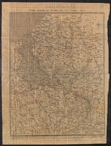
Published / Created
1914
Call Number
11hc 1914S
Format
Digital Collection / Online / Cartographic / Maps & GIS
Found In
Access
Public
Subject (Topic)
World War, 1914-1918

Container / Volume
BRBL_00010B
Published / Created
1940
Call Number
11hc 1915C
Format
Digital Collection / Online / Cartographic / Maps & GIS
Access
Public
Subject (Topic)
World War, 1914-1918--Maps
Creator
C.S. Hammond & Company
Container / Volume
BRBL_00037B
Published / Created
[ca. 1920]
Call Number
30fd 1920
Format
Digital Collection / Online / Cartographic / Maps & GIS
Found In
Access
Public
Subject (Topic)
World War, 1914-1918--Treaties

Creator
American Geographical Society of New York
Container / Volume
BRBL_00010J
Published / Created
[1918?]
Call Number
11hcf 1919-14
Format
Digital Collection / Online / Cartographic / Maps & GIS
Access
Public
Subject (Topic)
World War, 1914-1918--Maps

Creator
Encyclopaedia Britannica, inc and Matthews-Northrup Works
Container / Volume
BRBL_00010E
Published / Created
1918?]
Call Number
11hc 1917R
Format
Digital Collection / Online / Cartographic / Maps & GIS
Found In
Access
Public
Subject (Topic)
World War, 1914-1918--Maps
Creator
Encyclopaedia Britannica, inc and Matthews-Northrup Works
Container / Volume
BRBL_00010F
Published / Created
1918?]
Call Number
11hc 1918J-2
Format
Digital Collection / Online / Cartographic / Maps & GIS
Found In
Access
Public
Subject (Topic)
World War, 1914-1918--Maps

Creator
Encyclopaedia Britannica, inc and Matthews-Northrup Works
Container / Volume
BRBL_00010F
Published / Created
1918?]
Call Number
11hc 1918J
Format
Digital Collection / Online / Cartographic / Maps & GIS
Found In
Access
Public
Subject (Topic)
World War, 1914-1918--Maps
Creator
Ordnance Survey of Great Britain and Ireland and Royal Geographical Society (Great Britain). Geographical Section
Container / Volume
BRBL_00010ZA
Published / Created
1918
Call Number
11hcf 1919E-20
Format
Digital Collection / Online / Cartographic / Maps & GIS
Found In
Access
Public
Subject (Topic)
World War, 1914-1918--Maps
Creator
George Philip & Son and London Geographical Institute
Published / Created
[1918?]
Call Number
11hc 1914P
Format
Digital Collection / Online / Cartographic / Maps & GIS
Access
Public
Subject (Topic)
World War, 1914-1918--Maps

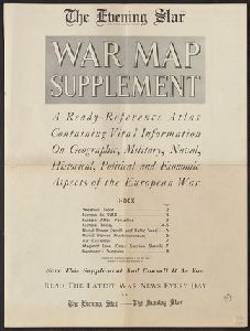
Published / Created
1918
Call Number
Ernst 2
Format
Digital Collection / Online / Mixed Material / Books
Access
Public
Subject (Topic)
World War, 1914-1918 --Poetry
Container / Volume
BRBL_00010C
Published / Created
[1918?]
Call Number
11hc 1915L
Format
Digital Collection / Online / Cartographic / Maps & GIS
Found In
Access
Public
Subject (Topic)
World War, 1914-1918--Maps
Container / Volume
BRBL_00010E
Published / Created
1918
Call Number
11hc 1918D
Format
Digital Collection / Online / Cartographic / Maps & GIS
Access
Public
Subject (Topic)
World War, 1914-1918--Maps
Creator
United States. Committee on Public Information
Container / Volume
BRBL_00010D
Published / Created
[1918]
Call Number
11hc 1917A
Format
Digital Collection / Online / Cartographic / Maps & GIS
Found In
Access
Public
Subject (Topic)
World War, 1914-1918--Maps

Creator
Horký, Karel, 1879-1965 and Lenhard, J
Container / Volume
BRBL_00032A
Published / Created
c1917.
Call Number
30 1917B
Format
Digital Collection / Online / Cartographic / Maps & GIS
Found In
Access
Public
Subject (Topic)
World War, 1914-1918--Maps

Creator
Stanford's Geographical Estabt
Published / Created
[1917?]
Call Number
11hc 1919W
Format
Digital Collection / Online / Cartographic / Maps & GIS
Found In
Access
Public
Subject (Topic)
World War, 1914-1918--Maps

Creator
Geological Survey (U.S.)
Container / Volume
BRBL_00173
Published / Created
1916?]
Call Number
38hc L337 1916
Format
Digital Collection / Online / Cartographic / Maps & GIS
Found In
Access
Public
Subject (Topic)
World War, 1914-1918 and World War, 1914-1918--Campaigns--France
Container / Volume
BRBL_00010C
Published / Created
1916
Call Number
11hc 1916HA
Format
Digital Collection / Online / Cartographic / Maps & GIS
Found In
Access
Public
Subject (Topic)
World War, 1914-1918--Maps

Container / Volume
BRBL_00010C
Published / Created
1916.]
Call Number
11hc 1916D
Format
Digital Collection / Online / Cartographic / Maps & GIS
Found In
Access
Public
Subject (Topic)
World War, 1914-1918--Maps
Published / Created
1916
Call Number
11hcf 1919B-37
Format
Digital Collection / Online / Cartographic / Maps & GIS
Found In
Access
Public
Subject (Topic)
World War, 1914-1918--Maps

Container / Volume
BRBL_00010C
Published / Created
1916
Call Number
11hc 1916H
Format
Digital Collection / Online / Cartographic / Maps & GIS
Found In
Access
Public
Subject (Topic)
World War, 1914-1918--Maps
Container / Volume
BRBL_00010C
Published / Created
1916
Call Number
11hc 1916HB
Format
Digital Collection / Online / Cartographic / Maps & GIS
Found In
Access
Public
Subject (Topic)
World War, 1914-1918--Maps
Creator
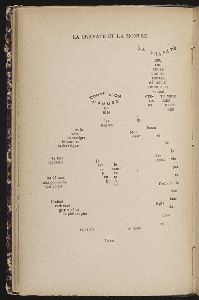
Marussig, Guido, 1885-1972, artist and Sillani, Tomaso, 1888-1915
Published / Created
[1916]
Call Number
2006 2057
Format
Digital Collection / Online / Mixed Material
Found In
Access
Public
Subject (Topic)
World War, 1914-1918 --Italy