Published / Created
circa 1995-2017
Call Number
VRC 1990a
Format
Digital Collection / Online
Found In
Access
Public

Published / Created
[1952]
Call Number
Poster0070
Format
Digital Collection / Online / Images
Found In
Access
Yale Community Only
Subject (Topic)
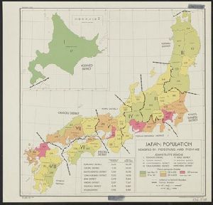
Population

Container / Volume
BRBL_00305
Description
"4 October 1944." "No. 5384-R & A, OSS." Shows population changes by prefectures.
Published / Created
1944
Call Number
57eb 1944
Format
Digital Collection / Online / Cartographic / Maps & GIS
Access
Public

Creator
United States. Office of Strategic Services. Research and Analysis Branch
Container / Volume
BRBL_00305
Published / Created
1945
Call Number
57eb 1940
Format
Digital Collection / Online / Cartographic / Maps & GIS
Found In
Access
Public
Subject (Topic)
Population density--Japan--Maps
Creator
United States. Office of Coordinator of Information. Geographic Division
Container / Volume
BRBL_00113
Published / Created
[1941]
Call Number
354eb 1941
Format
Digital Collection / Online / Cartographic / Maps & GIS
Found In
Access
Public
Subject (Topic)
Population density--Caucasus--Maps

Creator
United States. Office of Strategic Services
Container / Volume
BRBL_00087
Published / Created
1942
Call Number
335eb 1942
Format
Digital Collection / Online / Cartographic / Maps & GIS
Found In
Access
Public
Subject (Topic)
Population density--Belgium--Maps
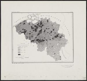
Creator
United States. Office of Strategic Services. Research and Analysis Branch
Container / Volume
BRBL_00023E
Published / Created
1944
Call Number
27eb 1930
Format
Digital Collection / Online / Cartographic / Maps & GIS
Found In
Access
Public
Subject (Topic)
Population density--Indonesia--Maps

Creator
Germany. Heer. Abteilung für Kriegskarten- und Vermessungswesen. IV. Mil.-Geo and Great Britain. Ordnance Survey
Container / Volume
BRBL_00075
Description
, and county boundaries. Population density shown by layer coloring. Relief shown by spot heights.
Published / Created
1940
Call Number
32eb 1940
Format
Digital Collection / Online / Cartographic / Maps & GIS
Access
Public
Subject (Topic)
Population density--England--Maps

Container / Volume
BRBL_00375B
Published / Created
191-?]
Call Number
73eb 1912
Format
Digital Collection / Online / Cartographic / Maps & GIS
Found In
Access
Public
Alternative Title
Atlas of Canada. and Density of population 1911 : British Columbia and Alberta.
Subject (Topic)
Population density--Canada, Western--Maps

Container / Volume
BRBL_00010S
Published / Created
1919]
Call Number
11hcf 1919B-5
Format
Digital Collection / Online / Cartographic / Maps & GIS
Found In
Access
Public
Subject (Topic)
Population density--Europe, Eastern--Maps

Published / Created
May 31, 1762
Format
Digital Collection / Online / Text / Archives or Manuscripts
Found In
Access
Public

Container / Volume
BRBL_00233A
Call Number
402eb 1836
Format
Digital Collection / Online / Cartographic / Maps & GIS
Access
Public
Subject (Topic)
Population density--Italy--Lombardy--Maps

Creator
United States. Office of Strategic Services. Research and Analysis Branch
Container / Volume
BRBL_00298
Published / Created
[1944]
Call Number
56eb 1944
Format
Digital Collection / Online / Cartographic / Maps & GIS
Found In
Access
Public
Subject (Topic)
Population density--China--Maps

Description
, China identified their population as 400 million. Text continues: On average one to two deaths every
Published / Created
[1930s]
Call Number
Poster0324
Format
Digital Collection / Online / Images
Found In
Access
Yale Community Only
Subject (Topic)
Public health, Mortality, China, Population, and Skulls
Description
, China identified their population as 400 million. Text continues: On average one to two deaths every
Published / Created
[1930s]
Call Number
Poster0323
Format
Digital Collection / Online / Images
Found In
Access
Yale Community Only
Subject (Topic)
Public health, Mortality, China, Population, and Skulls
Creator
United States. Office of Strategic Services. Research and Analysis Branch
Container / Volume
BRBL_00127
Published / Created
1945
Call Number
36eb 1945A
Format
Digital Collection / Online / Cartographic / Maps & GIS
Found In
Access
Public

Creator
Stiles, Ezra, 1727-1795
Container / Volume
Box 51, folder 2139
Published / Created
1765 August 5
Call Number
GEN MSS 1475
Format
Digital Collection / Online
Found In
Access
Public

Published / Created
1919?]
Call Number
11hcf 1919B-43
Format
Digital Collection / Online / Cartographic / Maps & GIS
Found In
Access
Public

Creator
United States. Office of Strategic Services. Research and Analysis Branch
Container / Volume
BRBL_00127
Published / Created
1945
Call Number
36eb 1945C
Format
Digital Collection / Online / Cartographic / Maps & GIS
Found In
Access
Public

Container / Volume
Box 1 | Folder 22
Published / Created
undated
Call Number
JWJ MSS 40
Format
Digital Collection / Online / Text
Found In
Access
Public

Creator
United States. Office of Strategic Services. Research and Analysis Branch
Container / Volume
BRBL_00127
Description
"No. 6357 - R & A, OSS, 10 April 1945." "Population data compiled in the Department of State
Published / Created
1945
Call Number
36eb 1939
Format
Digital Collection / Online / Cartographic / Maps & GIS
Found In
Access
Public

Creator
United States. Office of Strategic Services
Container / Volume
BRBL_00080
Published / Created
1942
Call Number
331eb 1942
Format
Digital Collection / Online / Cartographic / Maps & GIS
Found In
Access
Public

Creator
Atkins, Paul M. (Paul Moody), 1892-
Container / Volume
BRBL_00243
Published / Created
1910]
Call Number
41gc 1910
Format
Digital Collection / Online / Cartographic / Maps & GIS
Found In
Access
Public

Creator
Atkins, Paul M. (Paul Moody), 1892-
Container / Volume
BRBL_00243
Published / Created
1910]
Call Number
41gf 1910
Format
Digital Collection / Online / Cartographic / Maps & GIS
Found In
Access
Public

Call Number
Taylor 192 13
Format
Digital Collection / Online / Images
Found In
Access
Public
